| PID:
|
AK0721 |
| Designation:
|
IWBV 106 |
| Stamping:
|
IWBV 106 |
| Stability:
|
May hold commonly subject to ground movement |
| Setting:
|
Set in top of concrete monument |
| Mark Condition:
|
G |
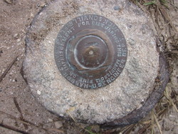
| Description:
|
This station is near the Bairs Cove Boat Ramp at the Haulover Canal Bridge. Follow Bairs Cove Rd and park at the bend, near the bridge. It is 15 ft SW of the SW corner of the NW wooden Garbage Can Box, 15.4 ft SW of a PVC fishing line container, 50 ft NE of the NE edge of the road, 62 ft NE of the centerline of the road, and 56.6 ft N of a right of way sign. It is a US Engineer Dept. Jacksonville Harbor Surveys Disk. The disk is 0.2 ft above the ground. |
| Observed:
|
2016-12-15T13:42:00Z |
more obs 1986
|
| Source:
|
OPUS - page5 1209.04 |
|
|
|
| Close-up View
|
|
| REF_FRAME:
NAD_83(2011) |
EPOCH:
2010.0000 |
SOURCE:
NAVD88 (Computed using GEOID18) |
UNITS:
m |
SET PROFILE
|
DETAILS
|
|
| LAT:
|
28° 44' 8.53379"
|
± 0.000
m |
| LON:
|
-80° 45' 17.14331"
|
±
0.002
m |
| ELL HT:
|
-26.105 |
±
0.004
m |
| X:
|
899210.197 |
±
0.002
m |
| Y:
|
-5524251.616 |
±
0.004
m |
| Z:
|
3048235.845 |
±
0.002
m |
| ORTHO HT:
|
2.048 |
±
0.051
m |
|
|
UTM
17 |
SPC
901(FL E) |
| NORTHING:
|
3178729.079m |
487763.521m |
| EASTING:
|
523946.709m |
223954.883m |
| CONVERGENCE:
|
0.11790362°
|
0.11790362°
|
| POINT SCALE:
|
0.99960708 |
0.99994826 |
| COMBINED FACTOR:
|
0.99961118 |
0.99995236 |
|
|
|
|
| Horizon View
|
|
|
|
|