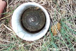
Shared Solution

PID: AJ8034
Designation: 3364B
Stamping: 3364B 1983
Stability: May hold, commonly subject to ground movement
Setting: Object driven into ground
Description: From the intersection of Highways 20 and 21 near Tolchester Beach, Kent County, Md., go westerly 3.3 miles to the Tolchester Marina, turn left, then right and travel to the tennis courts, and stop. Monument 3364B is on the right N 104.5 ft. from NW corner of wooden bulkhead, S 61.0 ft. from SE corner of fence around tennis courts and SE 14.9 ft. from the fence along said courts, in line with nets.
Observed: 2009-10-02T13:32:00Z more obs 2008-07-18 more obs Latest
Source: OPUS - page5 0909.08
Close-up View
REF_FRAME:   NAD_83(CORS96) EPOCH:   2002.0000 SOURCE:   NAVD88 (Computed using GEOID03) UNITS:  m  SET PROFILE   DETAILS
LAT: 39° 12' 53.10135" ±  0.011   m
LON: -76° 14' 36.23179" ±   0.009   m
ELL HT: -31.584 ±   0.013   m
X: 1176686.515 ±   0.010  m
Y: -4806321.939 ±   0.003  m
Z: 4010796.874 ±   0.017  m
ORTHO HT: 1.618 ±  0.035   m
UTM  18 SPC  1900(MD )
NORTHING: 4341344.556m 172117.050m
EASTING: 392656.524m 465340.266m
CONVERGENCE: -0.78618682° 0.47486942°
POINT SCALE: 0.99974188 0.99996730
COMBINED FACTOR: 0.99974683 0.99997226
CONTRIBUTED BY
dennis.a.warren
US Army Corps of Engineers
Horizon View
The numerical values for this position solution have satisfied the quality control criteria of the National Geodetic Survey. The contributor has verified that the information submitted is accurate and complete.