| PID:
|
AJ4721 |
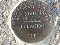
| Designation:
|
AFO |
| Stamping:
|
AFO |
| Stability:
|
Monuments of questionable or unknown reliability |
| Setting:
|
Pavement (street sidewalk curb etc.) |
| Mark Condition:
|
G |
| Description:
|
The bench mark is a disk set flush in the seawall near the SE corner of the fort, located 18.84 m (61.8 ft) NE of a chiseled square designated as MARION,
13.87 m (45.5 ft) WSW of the SE corner of the seawall, 1.37 m (4.5 ft) SSE of the north edge of the seawall and 2.38 m (7.8 ft) NNW of the south edge of the
seawall. |
| Observed:
|
2016-06-14T12:09:00Z |
more obs 2009-01-03
|
| Source:
|
OPUS - page5 1209.04 |
|
|
|
| Close-up View
|
|
| REF_FRAME:
NAD_83(2011) |
EPOCH:
2010.0000 |
SOURCE:
NAVD88 (Computed using GEOID18) |
UNITS:
m |
SET PROFILE
|
DETAILS
|
|
| LAT:
|
29° 53' 49.80713"
|
± 0.016
m |
| LON:
|
-81° 18' 39.14111"
|
±
0.017
m |
| ELL HT:
|
-25.829 |
±
0.007
m |
| X:
|
836027.961 |
±
0.016
m |
| Y:
|
-5470409.673 |
±
0.012
m |
| Z:
|
3160483.913 |
±
0.015
m |
| ORTHO HT:
|
2.802 |
±
0.052
m |
|
|
UTM
17 |
SPC
901(FL E) |
| NORTHING:
|
3307431.480m |
616509.849m |
| EASTING:
|
469986.126m |
169975.881m |
| CONVERGENCE:
|
-0.15495399°
|
-0.15495399°
|
| POINT SCALE:
|
0.99961111 |
0.99995229 |
| COMBINED FACTOR:
|
0.99961516 |
0.99995635 |
|
|
|
|
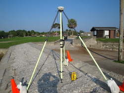
| Horizon View
|
|
|
|
|