| PID:
|
AI3224 |
| Designation:
|
872 9152 C TIDAL |
| Stamping:
|
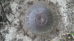
9152 C 1991 |
| Stability:
|
May hold commonly subject to ground movement |
| Setting:
|
Set in top of concrete monument |
| Mark Condition:
|
G |
| Description:
|
The bench mark is a disk set flush in the top of a concrete monument, 50 ft NE of the centerline of Thomas Drive, 10 ft N of utility pole number 60240-42753, 3.8 ft SW of a 6 ft chain link fence, and 3.6 ft SW of a fiberglass witness post. |
| Observed:
|
2020-02-14T22:59:00Z |
more obs 2020-02-18
|
| Source:
|
OPUS - page5 1801.18 |
|
|
|
| Close-up View
|
|