| PID:
|
AE9176 |
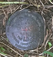
| Designation:
|
57 24 RESET |
| Stamping:
|
57 24 RESET 1973 STATE SURVEY RESET 1974 |
| Stability:
|
May hold commonly subject to ground movement |
| Setting:
|
A metal rod with base plate buried/screwed into ground |
| Mark Condition:
|
G |
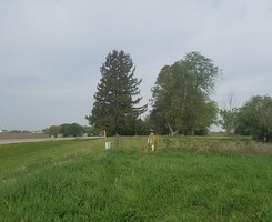
| Description:
|
From I380, east on Wright Brothers Blvd 1 mile (1.6 km) to mark on the left at fence east of barn. Mark is 7.5 ft N of a cable warning post, 7 ft N of a telephone box, 6.0 N of the face of the corner post, and 0.7 ft NNW of a witness post |
| Observed:
|
2018-05-17T13:16:00Z |
more obs 2018-03-28
|
| Source:
|
OPUS - page5 1603.24 |
|
|
|
| Close-up View
|
|
| REF_FRAME:
NAD_83(2011) |
EPOCH:
2010.0000 |
SOURCE:
NAVD88 (Computed using GEOID18) |
UNITS:
m |
SET PROFILE
|
DETAILS
|
|
| LAT:
|
41° 53' 26.21015"
|
± 0.003
m |
| LON:
|
-91° 39' 5.88164"
|
±
0.001
m |
| ELL HT:
|
224.161 |
±
0.011
m |
| X:
|
-137059.048 |
±
0.002
m |
| Y:
|
-4753311.387 |
±
0.006
m |
| Z:
|
4236716.729 |
±
0.009
m |
| ORTHO HT:
|
256.557 |
±
0.043
m |
|
|
UTM
15 |
SPC
1401(IA N) |
| NORTHING:
|
4638510.279m |
1045065.343m |
| EASTING:
|
611860.663m |
1653393.931m |
| CONVERGENCE:
|
0.90041111°
|
1.25271944°
|
| POINT SCALE:
|
0.99975397 |
1.00003661 |
| COMBINED FACTOR:
|
0.99971882 |
1.00000145 |
|
|
|
|
| Horizon View
|
|
|
|
|