| PID:
|
AE2766 |
| Designation:
|
866 6799 F TIDAL |
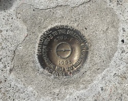
| Stamping:
|
6799 F 1993 |
| Stability:
|
Monument will probably hold position well |
| Setting:
|
Massive structures (other than listed below) |
| Mark Condition:
|
G |
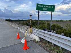
| Description:
|
The primary bench mark is a disk set in the deck of the old bridge, 1.13 m (3.7 ft) west of the NW leg of the sign for McKinley Washington Jr. Bridge, 0.3 m (1.0 ft) NE of the SW edge of the concrete deck of the bridge, and 0.09 m (0.3 ft) WNW of the NW edge of the concrete rail of the bridge. |
| Observed:
|
2023-07-29T00:17:00Z |
more obs 2023-09-13
|
| Source:
|
OPUS - page5 2008.25 |
|
|
|
| Close-up View
|
|
| REF_FRAME:
NAD_83(2011) |
EPOCH:
2010.0000 |
SOURCE:
NAVD88 (Computed using GEOID18) |
UNITS:
m |
SET PROFILE
|
DETAILS
|
|
| LAT:
|
32° 37' 53.87081"
|
± 0.019
m |
| LON:
|
-80° 20' 29.34766"
|
±
0.009
m |
| ELL HT:
|
-29.030 |
±
0.033
m |
| X:
|
902060.763 |
±
0.003
m |
| Y:
|
-5300377.909 |
±
0.039
m |
| Z:
|
3419609.840 |
±
0.008
m |
| ORTHO HT:
|
3.271 |
±
0.064
m |
|
|
UTM
17 |
SPC
3900(SC) |
| NORTHING:
|
3610642.120m |
88730.771m |
| EASTING:
|
561770.613m |
671391.634m |
| CONVERGENCE:
|
0.35510556°
|
0.36508056°
|
| POINT SCALE:
|
0.99964705 |
0.99995624 |
| COMBINED FACTOR:
|
0.99965161 |
0.99996080 |
|
|
|
|
| Horizon View
|
|
|
|
|