| PID:
|
AD1496 |
| Designation:
|
872 5791 2 |
| Stamping:
|
BM 2 |
| Stability:
|
Monuments of questionable or unknown reliability |
| Setting:
|
Pavement (street sidewalk curb etc.) |
| Mark Condition:
|
G |
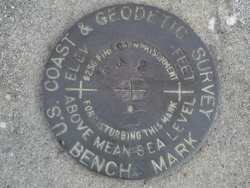
| Description:
|
The benchmark is a disk set in concrete, in the county park at Harbor Heights, 103.0' west of the SW. corner of the bathhouse, 78.5' SSE. of the SE. corner of a shuffleboard court, 73.5' NW. of the NW. corner of the main building and 0.5' West of the NW. corner of a concrete block used as a motor mount which is at the center of a 6.0' square slab. |
| Observed:
|
2017-05-22T12:40:00Z |
more obs 2016-02-29
|
| Source:
|
OPUS - page5 1603.24 |
|
|
|
| Close-up View
|
|
| REF_FRAME:
NAD_83(2011) |
EPOCH:
2010.0000 |
SOURCE:
NAVD88 (Computed using GEOID18) |
UNITS:
m |
SET PROFILE
|
DETAILS
|
|
| LAT:
|
26° 59' 18.32086"
|
± 0.012
m |
| LON:
|
-81° 59' 42.31028"
|
±
0.005
m |
| ELL HT:
|
-22.640 |
±
0.023
m |
| X:
|
792022.850 |
±
0.007
m |
| Y:
|
-5632030.647 |
±
0.014
m |
| Z:
|
2877062.232 |
±
0.021
m |
| ORTHO HT:
|
1.498 |
±
0.056
m |
|
|
UTM
17 |
SPC
902(FL W) |
| NORTHING:
|
2985542.066m |
294121.305m |
| EASTING:
|
401259.287m |
200487.741m |
| CONVERGENCE:
|
-0.45161715°
|
0.00222994°
|
| POINT SCALE:
|
0.99972036 |
0.99994118 |
| COMBINED FACTOR:
|
0.99972392 |
0.99994474 |
|
|
|
|
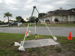
| Horizon View
|
|
|
|
|