| PID:
|
AC8378 |
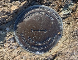
| Designation:
|
LIGHT RM 1 |
| Stamping:
|
-LIGHT NO 1 1982 |
| Stability:
|
Monument will probably hold position well |
| Setting:
|
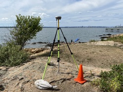
In rock outcrop or ledge |
| Mark Condition:
|
G |
| Description:
|
The bench mark is a disk set in a bedrock outcrop along the shoreline, 29.20 m (95.8 ft) SW of a 2.13 m (7.0 ft) circumference oak tree, 8.29 m (27.2 ft) NNE of bench mark LIGHT 1982, and 6.40 m (21.0 ft) west of the centerline of a track road. |
| Observed:
|
2022-07-31T18:58:00Z |
more obs 2022-09-19
|
| Source:
|
OPUS - page5 2008.25 |
|
|
|
| Close-up View
|
|
| REF_FRAME:
NAD_83(2011) |
EPOCH:
2010.0000 |
SOURCE:
NAVD88 (Computed using GEOID18) |
UNITS:
m |
SET PROFILE
|
DETAILS
|
|
| LAT:
|
41° 15' 0.93982"
|
± 0.009
m |
| LON:
|
-72° 54' 13.74808"
|
±
0.011
m |
| ELL HT:
|
-24.467 |
±
0.026
m |
| X:
|
1411761.849 |
±
0.011
m |
| Y:
|
-4590092.185 |
±
0.022
m |
| Z:
|
4183342.879 |
±
0.017
m |
| ORTHO HT:
|
5.480 |
±
0.065
m |
|
|
UTM
18 |
SPC
600(CT) |
| NORTHING:
|
4568657.825m |
198714.586m |
| EASTING:
|
675628.732m |
291908.169m |
| CONVERGENCE:
|
1.38246667°
|
-0.10199167°
|
| POINT SCALE:
|
0.99997963 |
0.99999531 |
| COMBINED FACTOR:
|
0.99998347 |
0.99999915 |
|
|
|
|
| Horizon View
|
|
|
|
|