| PID:
|
AC3334 |
| Designation:
|
872 3073 TIDAL 1 |
| Stamping:
|
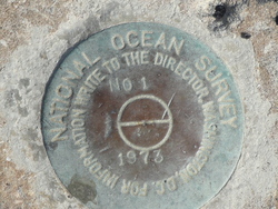
NO 1 1973 |
| Stability:
|
Monument will probably hold position well |
| Setting:
|
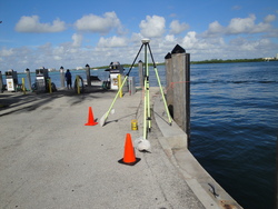
Massive retaining walls |
| Mark Condition:
|
G |
| Description:
|
The primary benchmark is a disk
recessed in asphalt near the fuel
pier at the Haulover Marina,
120.0' South of the centerline of
Pier #1, 36.0' east of the NW.
corner of the fuel pier, and about
level with the bulkhead. |
| Observed:
|
2017-06-24T13:18:00Z |
more obs 2010-10-22
|
| Source:
|
OPUS - page5 1603.24 |
|
|
|
| Close-up View
|
|
| REF_FRAME:
NAD_83(2011) |
EPOCH:
2010.0000 |
SOURCE:
NAVD88 (Computed using GEOID18) |
UNITS:
m |
SET PROFILE
|
DETAILS
|
|
| LAT:
|
25° 54' 13.74826"
|
± 0.016
m |
| LON:
|
-80° 7' 32.89753"
|
±
0.010
m |
| ELL HT:
|
-24.916 |
±
0.031
m |
| X:
|
984491.421 |
±
0.014
m |
| Y:
|
-5655920.335 |
±
0.031
m |
| Z:
|
2769469.925 |
±
0.007
m |
| ORTHO HT:
|
0.772 |
±
0.064
m |
|
|
UTM
17 |
SPC
901(FL E) |
| NORTHING:
|
2865324.298m |
174251.770m |
| EASTING:
|
587560.644m |
287590.530m |
| CONVERGENCE:
|
0.38192679°
|
0.38192679°
|
| POINT SCALE:
|
0.99969466 |
1.00003587 |
| COMBINED FACTOR:
|
0.99969857 |
1.00003978 |
|
|
|
|
| Horizon View
|
|
|
|
|