| PID:
|
AA7166 |
| Designation:
|
844 7435 B TIDAL |
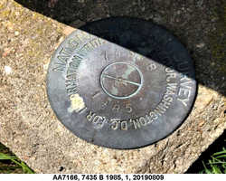
| Stamping:
|
7435 B 1985 |
| Stability:
|
May hold commonly subject to ground movement |
| Setting:
|
Footings of small/medium structures |
| Mark Condition:
|
G |
| Description:
|
The bench mark is a disk set in the grass near the NW side of a parking lot that is along the east side of Shore Rd, 39.01 m (128.0 ft) SSW of bench mark 7435 F, 37.72m (123.8 ft) WSW of the NW corner of the fish processing plant, 31.49 m (103.3 ft) SSW of the SW corner of the Chatham Pier fish market, 11.96 m (39.2 ft) east of the SE corner of the harbor master building, 7.69 m (25.2 ft) NW of a fire hydrant, and 3.56 m (11.7 ft) WSW of a light pole. |
| Observed:
|
2019-09-30T15:31:00Z |
more obs 2018-05-21
|
| Source:
|
OPUS - page5 1801.18 |
|
|
|
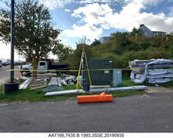
| Close-up View
|
|
| REF_FRAME:
NAD_83(2011) |
EPOCH:
2010.0000 |
SOURCE:
NAVD88 (Computed using GEOID18) |
UNITS:
m |
SET PROFILE
|
DETAILS
|
|
| LAT:
|
41° 41' 17.03789"
|
± 0.009
m |
| LON:
|
-69° 57' 5.43272"
|
±
0.006
m |
| ELL HT:
|
-24.235 |
±
0.018
m |
| X:
|
1635261.156 |
±
0.007
m |
| Y:
|
-4481039.544 |
±
0.019
m |
| Z:
|
4219777.311 |
±
0.005
m |
| ORTHO HT:
|
3.836 |
±
0.051
m |
|
|
UTM
19 |
SPC
2001(MA M) |
| NORTHING:
|
4615580.823m |
827593.406m |
| EASTING:
|
420814.172m |
328911.780m |
| CONVERGENCE:
|
-0.63285833°
|
1.04016667°
|
| POINT SCALE:
|
0.99967716 |
1.00000431 |
| COMBINED FACTOR:
|
0.99968096 |
1.00000811 |
|
|
|
|
| Horizon View
|
|
|
|
|