
 FGCS
Federal Geodetic Control Subcommittee
FGCS
Federal Geodetic Control Subcommittee
TEST AND DEMONSTRATION OF THE
TRIMBLE 4000 SSE GEODETIC
SYSTEM GPS SURVEYOR:
OCTOBER 1992
FGCS Report: FGCS-IG-94-2
December 1994
FGCS Members:
U.S. Department of Agriculture
U.S. Department of Commerce
U.S. Department of Defense
U.S. Army Corps of Engineers
U.S. Department of Interior
U.S. Department of Transportation
Environmental Protection Agency
Federal Aviation Administration
Federal Communications Commission
International Boundary and Water Commission
International Boundary Commission
National Aeronautics and Space Administration
National Capital Planning Commission
Tennessee Valley Authority
for information write:
CHAIRMAN, FEDERAL GEODETIC CONTROL SUBCOMMITTEE
Coast and Geodetic Survey, NOAA
N/CG, SSMC3, Room 8871
Silver Spring, Maryland 29010
Test and Demonstration of the
Trimble 4000 SSE Geodetic
System GPS Surveyor:
October 1992
FGCS Report: FGCS-IG-94-2
Larry Hothem
Robert Mann
Federal Geodetic Control Subcommittee
Instrument Working Group
Chair, Sally L. Frodge
For further information contact:
Secretariat, Federal Geodetic Control Subcommittee
N/CG, SSMC3, Station 8657
Coast and Geodetic Survey, NOAA
Silver Spring, Maryland 20910-3282
December, 1994
For sale by the National Geodetic Information Center, NOAA, Silver Spring, MD 20910-3282
The Federal Geodetic Control Subcommittee ran a test for evaluation of the Trimble 4000 SSE Geodetic Surveyor (TM) and associated data processing software in October, 1992. The dual frequency receivers were tested in static and rapid static operational modes. The post-processing software, GPSurvey (TM), was employed to process data in the field using the predicted (broadcast) ephemerides. Measured vectors ranged in length from 0.2 kilometers (km) to 104 km. Both static and rapid static modes yielded centimeter-level results. Selective Availability (SA) was on continuously during the test period. Anti-Spoofing (A-S) was activated during the first two days of the 4-day test. Neither SA or A-S had any significant impact on the results. Overall, the results from the use of the predicted (broadcast) ephemeris in the solutions indicate that the Trimble 4000 SSE Geodetic System Surveyor and the GPSurvey Software System will yield accuracies that meet or exceed the vendor's stated specifications.
In October, 1992, the Federal Geodetic Control Subcommittee (FGCS) conducted a test and demonstration of the Trimble 4000 SSE Geodetic System GPS Surveyor, a dual band (L1 and L2) receiver developed by Trimble Navigation, Limited. This was the seventeenth in a series of tests by FGCS to evaluate the capability and performance of Global Positioning System (GPS) geodetic satellite survey systems.
The goal of the October, 1992 FGCS campaign was to test the performance of the 4000 SSE Geodetic Surveyor receiver in conjunction with the GPSurvey baseline reduction package. Static and rapid static (FastStatic)™ positioning techniques were the focus of the test. The test and demonstration were conducted over a 6-day period beginning Sunday, October 4, and ending Friday, October 9, 1992. The test was run using stations of the FGCS test network located in the vicinity of Washington, D.C. (Hothem and Fronczek, 1983). Figure 1 is a sketch of the general layout of the FGCS test network. Many of the closely spaced stations are located within the grounds of the National Institute of Standards and Technology (NIST) in Gaithersburg, Maryland (Figure 2).
Figure 1. FGCS test network located in the vicinity of Washington, D.C.
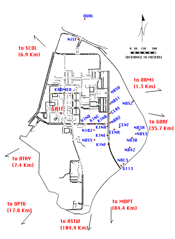
Figure 2. Portion of the FGCS test network near Gaithersburg, Maryland.
The 4000 SSE Geodetic Surveyor receiver provides L1 and L2 signal tracking of up to nine GPS satellites using parallel channels. One of the distinct features of the Geodetic Surveyor unit is the method it uses to overcome P-code encryption. The 4000 SSE tracks the P-code signal and full-cycle L1 and L2 carrier phase measurements when the P-code is available. During periods of A-S, the receiver maintains full-cycle L1 and L2 carrier tracking, and automatically switches from dual-frequency P-code tracking to precise C/A-code and cross-correlated Y-code operation. The 4000 SSE receiver can track and store dual-frequency code and full-cycle carrier phase measurements with P-code, or with the precise C/A-code and cross-correlated Y-code.
The GPSurvey processing software utilizes the precise code and carrier phase measurements collected with the Geodetic Surveyor unit for rapid static (FastStatic) surveys and high-accuracy long baseline estimation. The GPSurvey software suite runs under the Microsoft Windows operating system, version 3.1 or higher.
The status of the GPS satellite constellation, was obtained from information available from the Bulletin Board Service (BBS) of the United States Coast Guard (USCG) Navigation Information Center, formerly known as the GPS Information Center (GPSIC). This information is summarized in Table 1. The accuracy for the predicted (broadcast) satellite orbital coordinate data used in the baseline solutions was estimated to be about 1 mm/km (1 ppm) at the 1 sigma level.

Table 1. GPS satellite constellation status.
The FGCS test was conducted over four days: from Sunday, October 4, to Wednesday, October 7, 1992. Five Trimble 4000 SSE Geodetic Surveyor systems were deployed during the test. Observations were divided into two sections: static surveying, which was performed on Sunday, Monday, and Wednesday, (4-5, and 7 October), and rapid static surveying, which was conducted on Tuesday (6 October). Table 2 summarizes the static surveying observation schedule.
Today, the full GPS constellation is in orbit and observation times are readily available. During the GPS constellation build up, however, tighter planning was necessary to determine the appropriate observational windows that would provide a sufficient number of GPS satellites in view that provided reasonable satellite geometry relative to the observer. The observation times for the tests were in the afternoon (2 pm to 6 pm local time). Although there were brief periods when only 4 GPS satellites were available, there were several observation windows with at least 5 satellites that were 15 degrees above the horizon. Table 2 summarizes the satellite availability during the test. Table 3 presents the week's events at a glance.
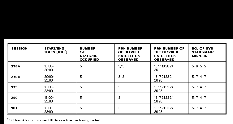
Table 2. Satellite availability during the FGCS Test.

Table 3. Test and demonstration calendar.
Initial Operational Capability (IOC) had not yet been declared for GPS when this test was run. Before IOC was declared, sporadic testing of A-S would occur. A-S was activated during this test on two days, 4 and 5 October. As mentioned, the 4000 SSEs employ the cross-correlation technique during periods of A-S, and the fact that A-S was implemented during the test allowed the receivers to be tested in that mode.
Short baselines were observed on Sunday (DAY 278), using two 2-hour observation sessions. The P-code was encrypted on five Block II satellites (PRNs 16, 17, 20, 23 & 26) throughout the DAY 278. All receivers automatically switched to C/A-code and cross-correlated Y-code tracking on the encrypted satellites. A mix of P-code, C/A-code and cross-correlated data was stored for later processing and analysis.
Medium length baselines, varying from 7 km to 42 km, were observed on Monday, DAY 279, using a single three hour session.
Long baselines of up to 104 km were observed on Wednesday, Day 281, during another single three hour session. Table 4 summarizes the stations occupied and the observations attempted and achieved.

Table 4: Static survey observations.
Return to List of Tables
RAPID STATIC (FastStatic) SURVEY FIELD OBSERVATIONS.
Rapid static surveys were conducted on DAY 281. The rapid static
surveying method improves productivity compared to static surveying
techniques by reducing site occupation time without significantly
compromising solution quality. The field occupations followed
the schedule as planned. Again, as was done for the static surveying,
receivers were pre-programmed and operators simply switched the
equipment on and started the predefined session. Rapid static
survey test operations utilized 2 rovers and 3 reference sites.
The rovers occupied one permanent control site for 5 separate
occasions and 2 other control sites on 4 separate occasions, for
a total of 13 site occupations and a total of 39 separate baselines.
The reference sites were approximately 0.5, 7 and 17 km away,
respectively, from the roving units. The range of baseline lengths
provided some breadth for the analysis of Trimble's FastStatic
technique.
An afternoon observing window from 2 pm until 6 pm local time provided reasonable satellite geometry for the receiver rapid static tests. Although there were brief periods where only 4 satellites were available, most of the time the observations were made during periods when only 5 satellites above 15 degrees were available. Rapid static survey occupation times varied from only a few minutes when 7 satellites were in view, to approximately 20 minutes when only 4 satellites were available. The 4000 SSE receiver has a screen that provides guidance to the receiver operator on how long a station must be occupied. This indicator uses the number of satellites available and other information to determine the suggested occupation time. Site occupation times that were used for the test were rather conservative, to insure that successful results would be obtained for the longest baseline of 17 km.
All processing and adjustment had been completed by Trimble personnel on site by the end of the day, on Thursday, 8 October, using the Trimble GPSurvey Data Processing System. This processing includes: 1] data download, 2] baseline reduction, 3] graphical viewing, and 4] network adjustment. The software has a structured, graphical interface to guide the operator through these steps. The results of this analysis were presented at a public meeting held on Friday afternoon, 9 October, 1992. The GPSurvey software is a suite of software packages allowing the user to download the GPS data, process baselines, view a graphical representation of the processed data and adjust a GPS network through use of a graphical user interface. The specific software packages used from the GPSurvey suite of programs were: Trimble's TrimVEC (TM) for static baseline processing, TrimKIN (TM) for kinematic processing, and TrimNET (TM) for the data adjustment. Icons, pull-down and pop-up menus and mouse support provide a user friendly environment. One hundred thirty-five rapid static and static baselines were processed and adjusted within a day of leaving the field.

Table 5. Results of three repeated vector measurements for the static surveys.
Table 6 summarizes three loop misclosure computations based on static survey results. The loops were formed using independently determined vectors, which were selected to provide uniform sampling in time and a mixture of baseline lengths. Only double difference solution were used, which were computed using the predicted satellite positions. The first closure included data from the mixed C/A code, cross-correlated Y-code, and P-code observations collected on DAY 278. This again supports the claim that the Trimble 4000 SSE can successfully operate under Y-code conditions, using the cross-correlation method. The resultant misclosure for all the solutions randomly examined by the FGCS ranged from 0.9 cm to 4.1 cm. Table 7 gives summaries for the static baseline closures for short, medium and long baselines.

Table 6. Summary of loop misclosure computations.

Table 7A. Static Baseline Solution Closure Summaries: Baselines <= 8 km.

Table 7B. Static Baseline Solution Closure Summaries: Baselines <=43 km.

Table 7C. Static Baseline Solution Closure Summaries: Baselines <= 84 km.
Tables 8A and 8B. Repeatability of the rapid static (FastStatic) baselines :

Table 8A. Over a 7.3 km baseline.
Return to List of Tables
Return to Contents

Table 8B. Over a 17 km baseline.
Return to List of Tables
Return to Contents
Each occupation was processed independently to obtain a vector
solution. Table 9 compares the results for repeated baselines.
The resultant of the horizontal position standard deviation did
not exceed 1.5 cm, while the vertical component was less than
2.0 cm. Given adequate satellite coverage and vectors shorter
than 17 km, the user should generally be able to achieve similar
results with the rapid static technique with these receivers,
the GPSurvey software and at least 15 minutes of occupation time.
To determine whether acceptable results can be attained reliably
for baselines longer than 20 km, additional testing is required.

Table 9. Comparison of repeat rapid static vector measurements.
Table 10 summarizes the published criteria for FGCS Orders III through AA. The capability of the Trimble 4000 SSE System Surveyor and the GPSurvey Software System to achieve the various orders are indicated. This is based on the analysis of the results of the FGCS test survey and assuming the accuracies for the broadcast and precise ephemerides of approximately 1 ppm and 0.1 ppm, respectively. The 4000 SSE was capable of tracking and storing dual frequency code and full cycle carrier phase measurements with P-code or with precise C/A code and cross-correlated Y code. The use of the cross-correlated Y-code technique offers a significant advantage in overcoming the effects of A-S. The remarks in Table 10 qualify the conditions upon which the standards are based. To achieve orders A and AA, it is assumed that the GPSurvey Software System is capable of producing results from fixed orbital coordinate data solutions that are limited only by the accuracy of the precise orbit data. It may be necessary to adjust the orbital elements of satellites in processing vectors to attain the highest classes of accuracy.
Overall, the results from the use of the predicted (broadcast) ephemeris in the solutions indicate that the Trimble 4000 SSE Geodetic System Surveyor and the GPSurvey Software System will yield accuracies that meet or exceed the vendor's stated specifications. Specifically, the test data were acquired with four or more satellites in an acceptable geometrical configuration, and with A-S implemented and with it not activated. The results support that the Trimble 4000 SSE System Surveyor can obtain FGCS Order B with the predicted (broadcast) ephemerides and Order A or possibly better with precise ephemeris information and careful reduction and analysis.
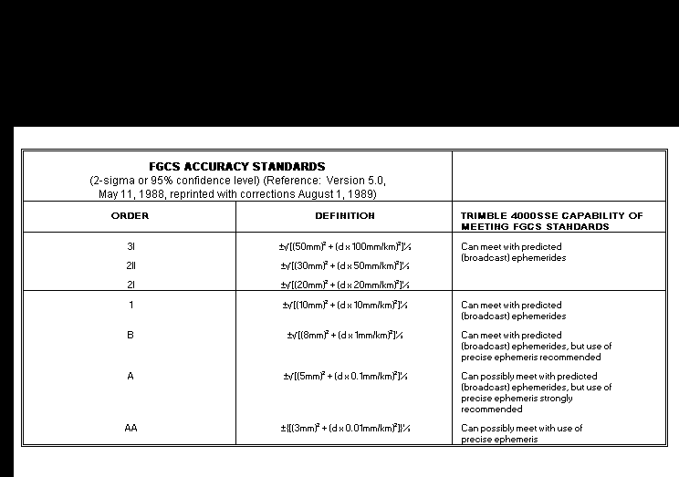
Table 10. Summary of FGCS Orders III through AA.
Grateful acknowledgement is given the following individuals supporting these FGCS activities:
Personnel representing Trimble Navigation during the test included: Mark Bardakjian, Phil Deaver, Brian Frohring, Ron Hyatt, Hugh Johnston, Michael Morris, Bruce Peetz, Tim Peterson, and Nicholas Talbot.
Personnel representing the FGCS included: R. Anderson, FGCS Test Coordinator, M. Bryant, J. Chase, S. Cofer, D. Crocket, S. DeLoach, A. Dragoo, J. Ferguson, S. Frodge, C. Fronczek, L. Hall, D. Hendrickson, C. Henkel, D. Hoar, L. Hothem, B. Leonard, B. Littell, J. Love, J. Pikulsky, J. Mean, D. Shultz, and G. Tuell.
Federal Geodetic Control Committee, 1984, reprinted 1991: Standards and Specifications for Geodetic Control Networks. September 1984, National Geodetic Survey Information Branch, NOAA, Rockville, MD 20852, 29 pp.
Federal Geodetic Control Committee, 1989: Geometric Geodetic Accuracy Standards and Specifications for GPS Relative Positioning Surveys. Version 5.0, May 1988, National Geodetic Survey Information Branch, NOAA, Rockville, MD 20852, 40 pp.
Federal Geodetic Control Committee, 1991, reprinted June 1991: Input Formats and Specifications of the National Geodetic Survey Data Base, Volume 1. National Geodetic Survey Information Branch, NOAA, Rockville, MD 20852, 250 pp.
Hothem, L.D., and Fronczek, C.J., 1983: Report on Test and Demonstration of MACROMETER (TM) Model V-1000 Interferometric Surveyor, FGCC Report IS-83-1, Federal Geodetic Control Committee. National Geodetic Survey Information Branch, NOAA, Rockville, MD 20852.
Hothem, L.D., 1990: Test and Demonstration of Three Dual Frequency (L1/L2) GPS Satellite Survey Systems, FGCC Report, IS-90-2, Federal Geodetic Control Committee. National Geodetic Survey Information Branch, NOAA, Rockville, MD 20852.
Milbert, Dennis G. and Kass, William, 1985: ADJUST: The horizontal observation adjustment program, NOAA Technical Memorandum, NOS/NGS-47.
White, Madeline B. and Love, John D., Submitting GPS Projects to the National Geodetic Survey: How and what?, Proceedings of the 1991 Fall Convention of the ACSM/ASPRS, Atlanta, GA, pp. 75-83.
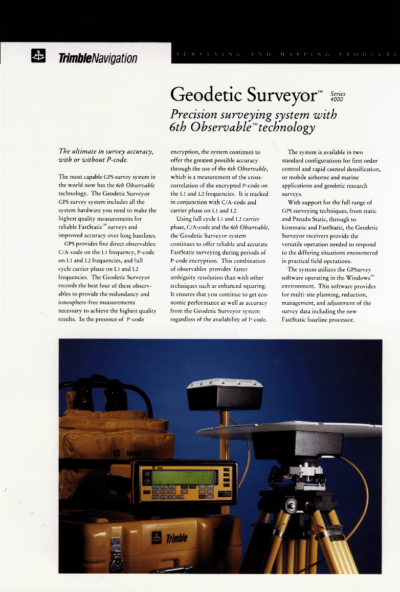
To view the image files for the Trimble 4000 SSE Geodetic Surveyor pamphlet, click on the page numbers below.
FGCS Geometric Accuracy Standards vs. Trimble 4000 SSE
To view the chart, click here(file size 16kb).
CHRONOLOGY OF EVENTS DURING FIELD OPERATIONS
FGCS observers and Trimble field personnel occupied 5 stations during the static surveys (4-5 and 7 October, 1992) and 3 reference and 2 rovers during the rapid static survey (6 October, 1992).
DAY 278
The 5 stations observed were NBS0, NBS1, NBS3, NBS5 and ORM1 for 2 sessions. The first session was from 1800 - 2000 UTC (1400 - 1600 Local time). The second session was from 2000 - 2200 UTC ( 1600 - 1800 Local time). The second session was scheduled to obtain redundant measurements for short baselines measured during the first session. The quality of the data for both sessions were acceptable for processing.
DAY 279
The 5 stations observed were NBS5, SCOL, ATHY, OPTK, and GORF. One session from 1900- 2200 UTC (1500 - 1800 Local time) was conducted. All 5 stations were observed with no problems noted.
DAY 280
Rapid static surveys were performed from 1800 - 2200 UTC (1400 - 1800 Local time). Reference receivers were set over NBS5, SCOL, and KINN. Two rovers were used. From 1800 - 2130 UTC (1400 - 1730 Local time), the first rover visited NBS2, NBS3, NB42, G113, and N102, without any problems. From 1800 - 2200 UTC (1400 - 1800 Local time), the second rover visited NBS2, NBS3, NB42, G113, N102, NBS2, NBS3, NB42, and G113. The first rover went on to occupy KIND, KINB, KINA, KINE, KINF, and KIND from 2130 - 2200 UTC (1730 - 1800 Local time).
DAY 281
The 5 stations were occupied for a single 3 hour session from 1900 - 2200 UTC (1500 - 1800 Local time). The stations were NBS5, GORF, MDPT, SCOL, and ASTW.
Number of GPS Satellites and PDOP
To view the charts, click here(file size 53kb).