Height
Modernization and GPS take off in the Classroom
The Jerstad-Agerholm Middle School GPS Club in Racine,
Wisconsin, had a week full of learning
and exploration. On April 27, 2005, they attended a meeting with Glen
Schaefer of the Wisconsin Department of Transportation (DOT) Height
Modernization Program funded through the National Oceanic and Atmospheric
Administration (NOAA) to learn about surveying and GPS. The club also attended a “geocaching” event,
“The Secrets of Stonehaven,” on April
30, 2005, at Harrington
Beach State Park. |
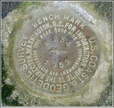
Mr. Schaefer instructed
the club participants on the importance of benchmarks and the use of
GPS in determining accurate elevations, the objective of NOAA’s
Height Modernization program. Benchmarks
are a type of survey mark used to specify a point on the ground whose
elevation, or height, relative to mean sea level, is known to the millimeter-level.
The state of Wisconsin,
as well as the rest of the United States,
uses benchmarks to establish accurate elevations for use by surveyors,
map makers, engineers, and others. The
students learned a number of things including, how to:
|
 |
- Correctly
identify a benchmark
- Determine
who set the benchmark
- Determine
if a benchmark is in need of repair
- Report
a damaged benchmark
- Correctly
care for a benchmark
|
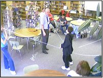
Mr. Schaefer also guided the students through a participatory
experience in the school’s library.
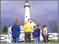
He then had the group reconvene at the Windpoint Lighthouse to
find, or “recover,” a benchmark on the lighthouse grounds. Mr.
Schaefer gave the participants various maps of Racine,
Racine County,
and the state of Wisconsin.
He also provided examples of benchmark “witness
posts,” signs, which help locate and protect the benchmarks. Mr. Schaefer then presented the school with
its own benchmark disk.
The students in the GPS club now have the necessary
experience to accurately report benchmarks they find to the Wisconsin
Height Modernization program. This
will assist Wisconsin
in determining if found benchmarks are correctly mounted or in need
or repair. Additionally, club members can provide a community
and state service by assisting in the surveying process for the state
of Wisconsin.
|
 |
The
Secrets of Stonehaven
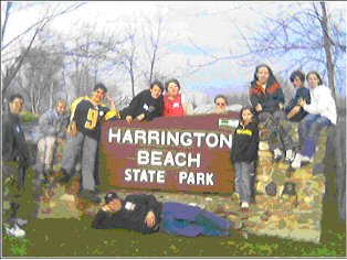
The GPS club continued their educational experience
by traveling to Harrington
Beach State Park
on April 30 to participate in a Geocaching
activity called “The Secrets of Stonehaven.”. The event featured 40
temporary geocaches, in three separate themes. |
| The day began with each student arriving
at school before 7:00 a.m. -- on a Saturday!
The club members split into two groups, with
each group pursuing one major theme of the geocaches during the morning
and afternoon “hunts.” Each student
had the opportunity to use GPS to lead their group and be the “first
finder” of a cache. The event concluded with group pictures and a raffle.
The Jerstad-Agerholm Middle School GPS Club was
one of the 94 teams present. There
were a total of 229 participants at the event. The day drew to a close
with the students returning to school tired, a little dirty, and really
excited about the day that they had.
|
The students now have experience in and
understanding of how GPS works and how to use it to find given coordinates.
They learned how to look for positive and negative
terrain features to aid in travel and personal safety. The students also learned how to participate
in the sport of “Geocaching” and how to effectively communicate and
work together as a team. |
The
Jerstad-Agerholm Middle School GPS Club
Special thanks to Mr. John Strack, Assistant Principal
and GPS Club Sponsor, Jerstad-Agerholm
Middle School,
for his contributions to this article.
|