| May 4 2024 |
|
||
|
 |
|
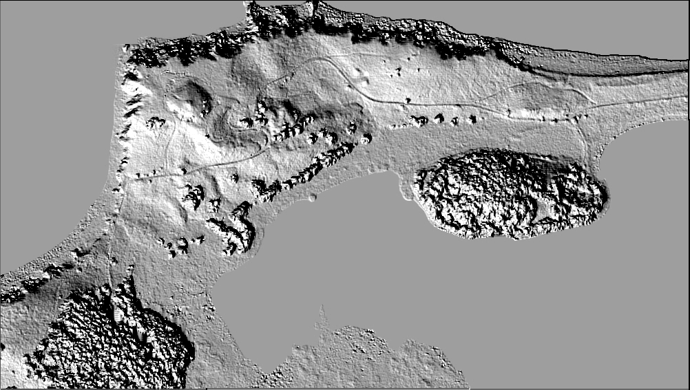
| The left image below is a shaded relief map representing the final Digital Surface Model (DSM). The DSM differs from a conventional elevation model in that the DSM heights are on top of the vegetation. The original data set was produced at 30cm post spacing, although the final product was down-sampled to the 1 meter resolution called for in the DTED-5 specifications. We performed an accuracy assessment of the DSM by comparing the auto-extracted heights to the heights measured manually by practiced photogrammetrists. We believe that this DSM (excluding the trees) is accurate in ellipsoid height to about 64 cm (1-sigma). Due to the conical shape of the Sitka Spruce, the trees are not as accurately determined (1-sigma accuracy is 1.4 meters). We believe that the horizontal coordinates of the data are accurate to the decimeter level. These accuracies were achieved by the execution of a specially configured photogrammetric project. We conducted a GPS field survey to place photo panels in the project area, and the photography was acquired at 3000 feet using 80% forward overlap. The aerial film was scanned at 12.5 microns, which yielded a pixel size of about 7 cm on the ground. The left photo shows a GPS receive set over one of the panels on the bluff. The right photo shows the NOAA Cessna Citation aircraft acquiring the photography under the clouds at a height of 3000 feet. |
| Digital Surface Model
(DSM) of Cape Chiniak, AK
|
|
| Although the vertical accuracy achieved does not meet the accuracy requirement of DTED-5 (30 cm), we are encouraged by these results. We believe that we have demonstrated that photogrammetric procedures can easily deliver high resolution DSM data that are accurate to the sub-meter level. We believe that data of this type may be useful in producing robust characterizations of the coastal environment, and in determining obstructions to the national airspace system. |
|
|
|
|
See a movie of the Kodiak, Alaska project site. File size is 7.13MB |
|
National Oceanic and Atmospheric
Administration/
National Ocean Service/ National Geodetic Survey Last modified: May 16 2017 |
|