| NGS personnel have recently completed a high resolution, 3-dimensional mapping project at Cape Chiniak, on Kodiak Island, Alaska. The project was a collaboration with the United States Air Force (USAF). The goal was to explore the use of digital photogrammetric techniques for the production of a LEVEL-5 Digital Topographic Elevation Data (DTED) product, in an area with complex coastal terrain. The image below is an orthophotograph that has been annotated to describe some features in the project area. The scene includes both sandy and rocky beaches, a high cliff, a shallow freshwater lake, and several groves of Sitka Spruce trees. The entire project area is covered in a 1-meter high grass. There is a WWII era bunker in the upper left of the scene. |
|
Chiniak Bay, AK Orthophotograph
|
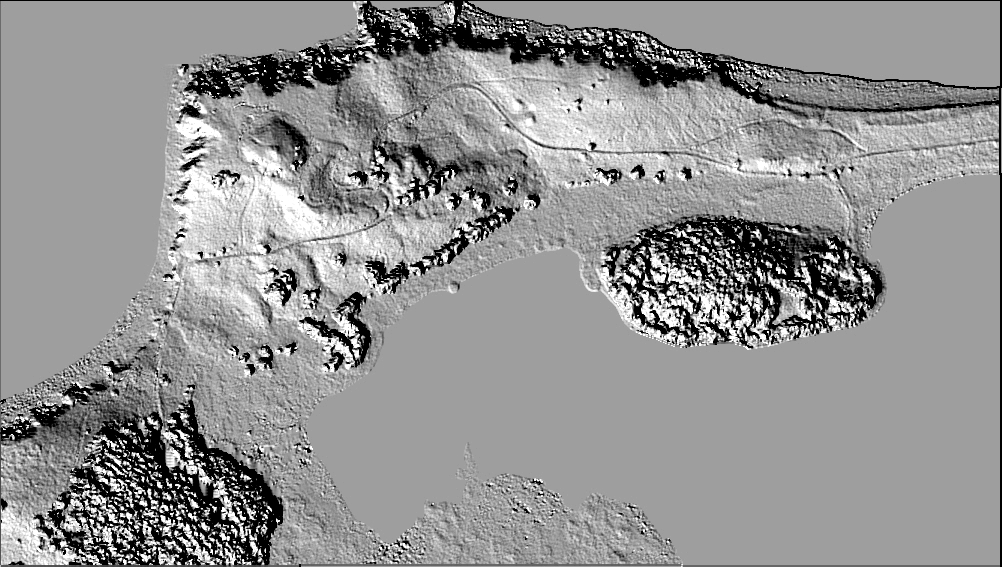
| The left image below is a shaded relief map representing the final Digital Surface Model (DSM). The DSM differs from a conventional elevation model in that the DSM heights are on top of the vegetation. The original data set was produced at 30cm post spacing, although the final product was down-sampled to the 1 meter resolution called for in the DTED-5 specifications. We performed an accuracy assessment of the DSM by comparing the auto-extracted heights to the heights measured manually by practiced photogrammetrists. We believe that this DSM (excluding the trees) is accurate in ellipsoid height to about 64 cm (1-sigma). Due to the conical shape of the Sitka Spruce, the trees are not as accurately determined (1-sigma accuracy is 1.4 meters). We believe that the horizontal coordinates of the data are accurate to the decimeter level. These accuracies were achieved by the execution of a specially configured photogrammetric project. We conducted a GPS field survey to place photo panels in the project area, and the photography was acquired at 3000 feet using 80% forward overlap. The aerial film was scanned at 12.5 microns, which yielded a pixel size of about 7 cm on the ground. The left photo shows a GPS receive set over one of the panels on the bluff. The right photo shows the NOAA Cessna Citation aircraft acquiring the photography under the clouds at a height of 3000 feet. |
| Digital Surface Model
(DSM) of Cape Chiniak, AK
|
|
| Although the vertical accuracy achieved does not meet the accuracy requirement of DTED-5 (30 cm), we are encouraged by these results. We believe that we have demonstrated that photogrammetric procedures can easily deliver high resolution DSM data that are accurate to the sub-meter level. We believe that data of this type may be useful in producing robust characterizations of the coastal environment, and in determining obstructions to the national airspace system. |
|
Chiniak Bay, AK Site Photograph
|
|
|
Click here to see a movie of the Kodiak, Alaska project site. File size is 7.13MB |
|
[NOAA Main Page] [NOS Main Page] [NGS Main Page] |
 |
National
Oceanic and Atmospheric Administration
National Ocean Service / National Geodetic Survey Remote Sensing Division This page updated on December 23, 1999 |