A current application of DEM data in airport survey planning is in preliminary obstruction analysis. Available DEM data, such as United States Geological Survey (USGS) 7.5-minute DEMs and National Imagery and Mapping Agency (NIMA) Digital Terrain Elevation Data (DTED), are used to quickly locate areas in which terrain penetrates the obstruction identification surfaces.
|
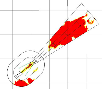
The image to the right shows the results of a terrain analysis for Heber City Municipal Airport, Heber, UT. The areas shown in red contain terrain which penetrates the FAR Part-77 or ANA obstruction identification surfaces. Areas shown in yellow contain terrain which comes within 50 feet of penetrating the surfaces. USGS 7.5-minute
DEMs were used in the Heber City analysis. The sources of USGS
DEM data are either digitized 1:24,000 scale maps (Level 1) or photogrammetry
(Level 2). The horizontal resolution of the DEMs is 30 meters.
|
|
As indicated in the image, an exceptionally
large portion of the ANA approach to runway end 21 at Heber City Municipal
Airport is obstructed by terrain. This analysis enabled cartographers in
NGS' Remote Sensing Division to contact FAA officials who modified the
survey requirements based on the results. Weeks of planning and survey
time were saved due to the analysis. To date, the automated obstructing
terrain analysis has been used in planning over 20 airport obstruction
surveys. Personnel in NGS' Remote Sensing Division continue to investigate
time saving applications for existing DEM data.
|
[NOAA Main Page] [NOS Main Page] [NGS Main Page] |
 This
page updated on December 23, 1999
This
page updated on December 23, 1999