| May 17 2024 |
|
||
|
 |
DEM Applications Study
Background
| The Aeronautical Survey Program of the National Geodetic Survey provides source airport obstruction data used to develop runway approach procedures, determine takeoff weights, and support activities such as aircraft accident investigations. An obstruction is defined as any object, including terrain, that penetrates the FAA Federal Aviation Regulations (FAR) Part-77 or area navigation approach (ANA) Obstruction Identification Surfaces (OIS). The obstruction data are obtained using field survey and photogrammetric methods. |
| Objectives
This study analyzes applications for digital
elevation models (DEMs) in the Aeronautical Survey
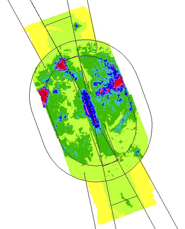
A significant advancement in the integration of DEM data into the program is the current ability to analyze digital elevation data sets relative to the FAR Part-77 and ANA obstruction identification surfaces (see right image). The analysis uses runway and approach data contained in NGS' Obstruction Chart Database (OCDB) and existing Fortran algorithms running on a DEC VAX 4000 to mathematically model the FAR Part-77 and ANA OIS and test each data point in the DEM for penetration. The automated terrain analysis program can be used to create a digital elevation file which models the intersection of the two surfaces: terrain and the OIS. |
|
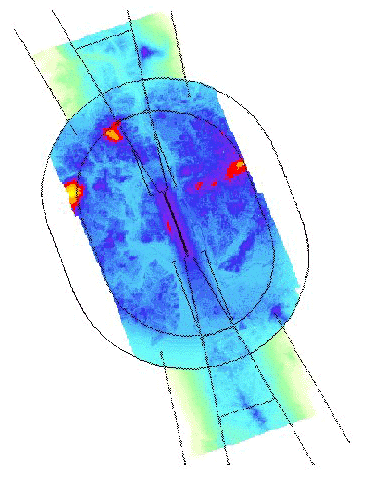
| Shown below are the results of a new, automated FAR Part-77 analysis of Asheville Regional Airport, Asheville, North Carolina. The digital surface model (DSM) used for this analysis was created by the NGS Remote Sensing Division as part of a joint project with the FAA and the National Aeronautics and Space Administration (NASA). The aerial photography used to create the DSM was obtained by NOAA's Cessna Citation II aircraft at 15,000 feet. A pixel size of 12.5 microns was used in scanning the photography. The DSM was produced on a 5-meter horizontal grid using Softplotter software. |
|
|
In the thematic map of the airport and
survey surfaces shown here at left, shades of red indicate areas in which
terrain or elevated objects (trees, buildings, etc) penetrate the obstruction
identification surfaces. Shades of blue, green, and yellow indicate areas
in which the terrain and elevated objects fall below the surfaces. Typically,
DEM data contains ground elevations, and does not account for elevated
objects. A major advantage to using this type of DSM for obstruction analysis
is the ability to map elevated objects, such as trees, which penetrate
the surfaces. In addition, the 5-meter grid postings permit a much more
detailed obstruction analysis than lower-resolution DEMs.
|
Fly through movie of Asheville project site, Warning file size is 10.2MB
Other examples
Heber
City, UT analysis
Future
DEM applications in the Aeronautical Survey Program
Alternate technologies in airport obstruction charting
Harrisburg,
Pennsylvania Technology Validation Site
|
National Oceanic and Atmospheric
Administration/
National Ocean Service/ National Geodetic Survey Last modified: May 16 2017 |
|