Converting GPS Height into NAVD88 Elevation with the GEOID96 Geoid Height Model
Dennis G. Milbert, Ph.D. and Dru A. Smith, Ph.D.
National Geodetic Survey, NOAA
ABSTRACT
The Global Positioning System (GPS) is commonly considered a three-dimensional system. But,
the heights obtained from GPS are typically heights above an ellipsoidal model of the Earth.
These GPS ellipsoidal heights are not consistent with leveled heights above mean sea level, often
known as orthometric height. The conversion from ellipsoid to orthometric height requires a
geoid height model. Geoid heights in the conterminous United States range from about -8 meters
to -53 meters, and display considerable variation in the mountains. Through the use of careful
GPS survey procedures coupled with high-resolution geoid models, surveyors have obtained
orthometric heights with an accuracy commensurate with that of leveling.
In mid-October the National Geodetic Survey will release the GEOID96 geoid height model. It is
computed with nearly 1.8 million terrestrial, ship, and altimetry gravity data, and is modeled on a
2' x 2' grid (about 3 km resolution). GEOID96 is fundamentally different from the earlier
GEOID90 and GEOID93 models, in that over 2700 GPS heights on leveled benchmarks are used
as a supplemental data set. These GPS benchmark data capture datum definition issues inherent
in NAD 83 ellipsoid heights and NAVD 88 orthometric heights, and also provide control of long
wavelength geoid model error. While the GEOID96 model is biased relative to a geocentric
ellipsoid, this bias is deliberate; and, it enables one to directly convert between NAD 83 GPS and
the NAVD 88 height systems. Tests of preliminary models show this conversion can be done to
better than 3 cm (one-sigma), and that random error in GPS height is of greater concern.
INTRODUCTION
The impact of the Global Positioning System (GPS) is undeniable. In the span of just a few years
GPS has become the leading positioning technology. This revolution has not been confined to the
surveying community, but has extended into mapping, navigation, and Geographic Information
System (GIS) arenas. We are witnessing widespread adoption of GPS with an equivalently
widespread range of accuracy requirements. Many of these applications require accurate vertical
positioning. And, a common requirement is the transformation of GPS heights into heights above
mean sea level. In this paper we review height relationships and vertical datums, and show how
the GEOID96 model was developed to convert between height systems.
HEIGHT RELATIONSHIPS
The procedure of geodetic leveling provides a height that is commonly known as a height above
mean sea level. In this process, level differences, which express the alignment of a level bubble,
are combined with surface gravity readings to obtain final values. Formally, heights from geodetic
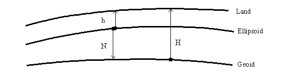
leveling are known as orthometric heights, and are denoted H (Figure 1). It should come as no
surprise that orthometric heights will reflect local variations in gravity as well as changes in
topography. The reference surface for orthometric heights is a level surface of the Earth that is
closely associated with mean sea level on a global basis. This particular level surface is called the
geoid. Orthometric heights are the vertical distance from the geoid to the surface of the Earth.
And, by convention, the sign is considered positive as one moves radially outward.
GPS, on the other hand, produces a much different kind of height. Whether one uses point,
differential, or differenced carrier phase positioning, one obtains a set of XYZ coordinates that
depend upon locations of base stations and satellite positions. These three-dimensional,
geometric relationships, in contrast to geodetic leveling, do not depend on local gravity variations.
Since XYZ coordinates do not directly express the notion of height, it is necessary to transform
them into a different coordinate system. Typically, XYZ are transformed into geodetic latitude,
longitude and ellipsoidal height. This transformation is performed using a very simple, two-parameter, model of the Earth: the ellipsoid. The ellipsoid heights obtained from the
transformation are denoted h.
These height relationships are portrayed in Figure 1. The difference between GPS ellipsoid
heights, h, and leveled orthometric heights, H, is called geoid height, N. As seen in the figure, the
geoid height is the vertical distance from the ellipsoid to the geoid level surface. These heights
obey a simple equation
h = H + N .
Figure 1 illustrates the relative alignment of the surfaces in the conterminous United States. Here, the geoid surface is beneath the ellipsoid. Thus, geoid heights are negative, and the ellipsoidal height is smaller in magnitude than the orthometric height at a given point. As an example, if one is near the seashore, orthometric height may only be +1 meter, while the ellipsoid height may be -30 meters. In this case, the ellipsoid surface would be overhead.
Figure 1. -- Types of Heights.
As implied in the last paragraph, the differences between ellipsoidal height, h, and orthometric
height, H, are sizable. These differences, h-H, are the geoid height. Globally, geoid heights can
range from about +75 to -100 meters. In the conterminous United States, geoid heights vary
from -8 to -53 meters. In addition to this considerable magnitude, the variation is extremely
complex. This complexity relates to topographic relief as well as subsurface rock density
variations. Because of this complexity, high resolution geoid models, and associated interpolation
software, have been developed to support GPS height conversion.
It is a straightforward procedure to algebraically subtract an interpolated geoid height, N, from a
GPS ellipsoidal height, h, to obtain an orthometric height, H:
H = h - N .
However, when this is done on a point by point basis, the results often display a systematic offset
in H for a given region (Milbert 1991). The cause of this offset is predominantly due to datum
definition.
DATUMS AND REFERENCE SYSTEMS
The simple expressions shown above are built on an underlying assumption. That is, it is assumed that the quantities are referred to a common reference system. However, it is necessary to realize a reference system through measurements and definitions. Often, this realization of a system is referred to as a datum. Height datums can be inconsistent due to measurement error or definitional issues. These effects generally operate as a near-constant bias in a given area. At different levels of accuracy, height bias, or datum ambiguity, is evident in all three height components: ellipsoidal, orthometric, and geoid. The situation is best expressed by the equation:
![]()
where the new terms indicate height bias in each component. Let us consider each of the three
height systems.
Ellipsoidal Height Bias
The principal cause of systematic bias in ellipsoidal heights is the non-geocentric realization of a
reference system. In particular, it is known that the NAD 83 (86) reference system is non-geocentric. While being primarily a horizontal, classical network, the NAD 83 (86) was controlled
by VLBI and Doppler data sets, and this subset can be considered three-dimensional. Dr. Richard
Snay, National Geodetic Survey, has computed a seven parameter Helmert transformation from
NAD 83 (86) to ITRF94(1996.0) with 8 points common to both reference systems. The results
are summarized in Table 1. The RMS of fit was 13 millimeters (mm).
| Table 1 -- Transformation from NAD 83 (86) to ITRF94(1996.0) | |||
| X shift | -0.9738 | ±0.0261 | m |
| Y shift | +1.9453 | ±0.0215 | m |
| Z shift | +0.5486 | ±0.0221 | m |
| X rotation | -0.02755 | ±0.00087 | arc sec |
| Y rotation | -0.01005 | ±0.00081 | arc sec |
| Z rotation | -0.01136 | ±0.00066 | arc sec |
| scale | -0.00778 | ±0.00264 | ppm |
Figure 2 portrays the datum differences between NAD 83 (86) and ITRF94(1996.0) ellipsoidal heights referred to the GRS80 ellipsoid. It is seen that the non-geocentricity of the NAD 83 (86) reference frame induces a smooth, systematic difference in ellipsoidal heights. The values in the U.S. range from -0.28 to -1.64 m, and have an average tilt of about 0.3 ppm.
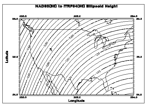
Figure 2. -- Ellipsoid height differences between NAD 83 (86) and ITRF94(1996).
Orthometric Height Bias
The NAVD 88 datum was realized by a single datum point, Father Point/Rimouski, in Quebec,
Canada. A number of factors entered into selection of the datum and its adopted value. But, the
primary requirement was to minimize the recompilation of national mapping products (Zilkoski et
al. 1992). There was no guarantee that the NAVD 88 datum corresponds to the theoretical level
surface defined by the GRS80 definitions. A recent study by Rapp (1996) compares ITRF93 GPS
positions and a global geopotential model against the NAVD 88 vertical datum. Rapp found a
mean offset for the NAVD88 datum of -27 cm when computed with a set of 397 GPS points.
The sense of the offset is portrayed in Figure 3.
     __________________________________________________   Global Geoid Model


                            27 cm

     __________________________________________________   NAVD 88 Reference
Figure 3. -- NAVD 88 offset.
Geoid Height Bias
Modern high resolution geoid height models are invariably computed by a remove/restore
technique (Schwarz et al., 1990). In this process, a global geopotential model is evaluated to
obtain base geoid and gravity anomaly grids. Measured gravity data are reduced and the base
gravity anomalies are subtracted in the removal stage. Some type of Fast Fourier Transform
(FFT) technique is used to evaluate Stokes integral, and the residual geoid quantities are added
back to the base geoid grid in the restore stage. However, due to its problematic nature, most
practitioners do not perform trend removal prior to invocation of the FFT. While such trends are
small, their spectrum will be folded, or aliased, across the recoverable frequency band (Hamming
1989, pp. 224-227). This effect is expected to be of long wavelength, and certainly deserves
future study by the geodetic community.
THE GEOID96 AND G96SSS GEOID MODELS
Because of the increasing use of GPS in the United States for both horizontal and vertical positioning, the National Geodetic Survey (NGS) must support the surveying, mapping, navigational, and GIS communities in obtaining heights referred to the NAVD 88 datum using GPS technology. Studies by Milbert (1995) have found that it is possible to relate a given high-resolution gravimetric geoid model to the reference system of GPS ellipsoidal heights and to the vertical datum of an orthometric height system by means of an empirical conversion surface. Such conversion values, s, contain the datum definition and realization problems discussed above. Formally,
![]()
It is possible to absorb the datum biases contained in the conversion surface, s, into a gravimetric geoid model, N. If this is done, then a new geoid model, denoted N96, is obtained.
![]()
The advantage of such a geoid model is that it will support direct conversion between an ellipsoidal reference system and orthometric vertical datum, even if they are not defined on a common reference. This procedure was followed in GEOID96. If subscripts are used to denote the datums associated with the height systems, then we may write:
![]()
The equation shown above is the conversion we supply to our users. The major component of the
datum definition error is the non-geocentricity of NAD 83, illustrated in Figure 2. In essence,
GEOID96 has been defined relative to a non-geocentric ellipsoid. Alternatively, it is correct to
state that GEOID96 is biased with respect to a geocentric ellipsoid. However, this bias is
deliberate. GEOID96 supports the direct conversion between NAD 83 GPS heights and NAVD
88 orthometric heights.
The technique for obtaining the gravimetric geoid model, G96SSS, is to use gravity data to
compute high frequency corrections to an existing model of the Earth's geoid heights. This base
model was obtained by evaluating the new, EGM96, global geopotential model computed by the
joint NASA Goddard Space Flight Center and DoD Defense Mapping Agency project (Rapp and
Nerem 1994). By means of a one-dimensional, spherical FFT algorithm, we computed the high
frequency geoid component from nearly 1.8 million point gravity data in the NGS data base. The
high frequency geoid grid was combined with the EGM96 geoid heights, and a correction derived
from digital terrain data, to yield the final gravimetric geoid heights. We are particularly grateful
for the support of the Defense Mapping Agency in supplying certain gravity and digital terrain
data.
The technique for obtaining the GEOID96 geoid model in the conterminous United States is to compute an empirical conversion surface that is added to the G96SSS model. We first compute the departures of the G96SSS geoid heights from the NAD 83 ellipsoid heights and NAVD 88 orthometric heights at nearly 3000 points. We remove a tilted plane trend, which captures the non-geocentricity of the NAD 83 (86) reference system, as well as vertical datum bias in NAVD 88. Then an empirical covariance function is fit to the covariance statistics of the detrended geoid residuals (Figure 4). The fit is made using a simple function of the form
![]()
where d is the spherical distance between points; characteristic length, L = 400 km; and function variance C0 = (9.7)2 cm2. Through collocation, predictions of the detrended residuals are made on a regular grid. In the prediction, GPS heights are assigned a random noise component of 5.8 cm. The trend is then restored to prediction grid, generating the final empirical conversion surface (See Figure 5 for an example). The similarity of the conversion surface and the non-geocentric effect in Figure 2 is evident.
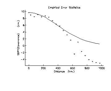
Figure 4. -- Sample empirical covariance function fit.
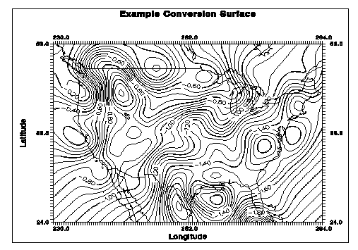
Figure 5. -- Example of a conversion surface between GEOID96 and G96SSS.
The smoothness of the conversion surface is remarkable. This is directly related to the long characteristic length, L = 400 km, that was obtained in the function fit. The conversion surface incorporates datum definition effects, as well as smoothly varying errors in ellipsoid, orthometric, and geoid height. A shaded relief image of a preliminary version of GEOID96 is shown in 6.
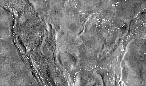
Figure 6. -- Preliminary version of GEOID96 geoid height model.
RESULTS WITH THE GEOID96 PROCEDURE
Our objective has been to develop a geoid model that directly converts between the inconsistent definitions of our height systems. To evaluate a preliminary GEOID96 model, the relationship
![]()
was tested at 2729 GPS points on leveled benchmarks. It was found that the RMS error was 5.8
cm, with no offsets or trends removed. Thus, the conversion process is seen to be quite
successful.
Perhaps of even more interest, the covariance statistics for the residuals to the preliminary GEOID96 model were computed, and an empirical covariance function was then developed. These results are portrayed in Figure 7. Unlike Figure 4, which was plotted to a distance of 1000 km, Figure 7 is only plotted out to 100 km. At this much closer scale, a drop is seen in the statistics from 5.8 cm at d = 0, down to 2.6 cm at d = 5 km. This reduction is evidence of an uncorrelated (white-noise) process. The source of the 5.8 cm of uncorrelated error is random error in the GPS ellipsoidal heights. The sources of the 2.6 cm of correlated error are not obvious, but geoid error is certainly one component. Further discussion on the error sources can be found in Milbert (1995).
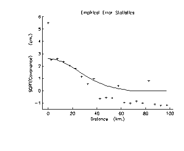
Figure 7. -- Empirical covariance function fit, preliminary GEOID96 model.
In closing this section, two points must be made. The GEOID96 model does not eliminate the
need for leveled benchmark ties in geodetic surveys. However, one should obtain better results
with adjustment procedures (as described in Milbert 1991) when benchmark distribution is not
ideal. And, it has been found that particular care must be taken to get accurate GPS ellipsoidal
heights. Zilkoski (1996), for example, gives guidelines that address numerous error sources; such
as antenna phase center variation with elevation angle, tropospheric scaling parameters, and
multipathing.
CONCLUSIONS
Gravimetric geoid models, such as GEOID93 or G96SSS, show systematic departures from NAD
83 GPS ellipsoidal heights at leveled benchmarks with NAVD 88 orthometric heights. These
departures are dominated by datum definition and datum realization problems. It is possible to fit
these departures into a very smooth conversion surface, and add this surface to a gravimetric
geoid model. The GEOID96 geoid height model, which incorporates such a conversion surface,
displays about 2.5 cm of accuracy (one sigma) between points spaced at 50 km or greater. GPS
ellipsoidal height error of about 6 cm was observed after the computations.
AVAILABILITY
The geoid height and deflection of the vertical components have a target release date of mid-October 1996. They will be available on a single CD-ROM from the NGS Information Services Branch. GEOID96 is organized into 9 regions; 6 for the conterminous United States, and the remainder for Alaska, Hawaii, Puerto Rico, and the Virgin Islands. The GEOID96 model in the conterminous United States incorporates NAD 83 GPS heights on NAVD 88 benchmarks. For specialized studies, the G96SSS gravimetric geoid model is supplied in 6 regions covering the conterminous United States. The DEFLEC96 model, which is compatible with the GEOID96 model, is organized in 17 regions; spanning the conterminous United States, Alaska, Hawaii, Puerto Rico, and the Virgin Islands. In addition to the CD-ROM, users may obtain regional groupings individually on diskette. These models will also be available for anonymous FTP access at ftp.ngs.noaa.gov; on the World Wide Web at http://www.ngs.noaa.gov; and on the electronic bulletin board system -- telephone 301-713-4181 and 301-713-4182 (8-bit, no parity, 1 stop bit, 300 to 14400 baud). For more information, please contact:
     Information Services Branch
     National Geodetic Survey, NOAA, N/NGS12
     1315 East-West Highway, Station 9202
     Silver Spring, MD 20910-3282
     Phone: 301-713-3242; Fax: 301-713-4172
REFERENCES
Hamming, R. W., 1989: Digital Filters, Third Edition. Prentice-Hall, Inc., Englewood Cliffs, 284
pp.
Milbert, D.G., 1995: Improvement of a high resolution geoid height model in the United States
by GPS height on NAVD 88 benchmarks. In: Balmino G., F. Sanso (ed), New Geoids in the
World, International Association of Geodesy, Bulletin d'Information N. 77, IGeS Bulletin N. 4,
13-36.
Milbert, D. G., 1991: Computing GPS-derived orthometric heights with the GEOID90 geoid
height model. Technical Papers of the 1991 ACSM-ASPRS Fall Convention, Atlanta, Oct. 28 to
Nov. 1, 1991. American Congress on Surveying and Mapping, Washington, D.C., pp. A46-55.
Moritz, H., 1992: Geodetic Reference System 1980. Bull. Geod., 66(2), 187-192.
Rapp, R.H., 1996: Use of potential coefficient models for geoid undulation determinations using
a spherical harmonic representation of the height anomaly/geoid undulation difference. Submitted
to Journal of Geodesy.
Rapp, R. H. and R. S. Nerem, 1994: A joint GSFC/DMA project for improving the model of the
Earth's gravitational field. Presented at Joint Symposium of the International Gravity Commission
and the International Geoid Commission, Graz, Austria, September, 1994.
Schwarz, K.P., M.G. Sideris, and R. Forsberg, 1990: The use of FFT techniques in physical
geodesy. Geophysical Journal International, 100, pp. 485-514.
Zilkoski, D.B., 1996: Guidelines for establishing GPS-derived ellipsoid heights (Standards: 2 cm
and 5 cm), Version 4.1. Internal Draft Document. National Geodetic Survey, Silver Spring, MD.
Zilkoski, D.B., J.H. Richards, and G.M. Young, 1992: Results of the general adjustment of the North American Vertical Datum of 1988. Surv. and Land Info. Sys., 52(3), 133-149.