RELATIVE TO THE CONTINUOUSLY OPERATING REFERENCE STATIONS
The establishment of the Continuously Operating Reference Station (CORS) network has provided the user community with a set of vastly improved positional coordinates. Data from these CORS sites are accessible through the INTERNET and, with the proper procedures, can be used in conjunction with GPS observations to densify the High Accuracy Reference Network (HARN). A nationwide A-Order GPS survey has recently been observed and analyzed. This survey provides ties between the CORS network and the HARN throughout the conterminous United States. In this paper, I will discuss the magnitude of the horizontal positional discrepancies thus found between CORS and HARN sites. In addition, I will discuss the methods that were used to reduce most of the larger discrepancies. Finally, I will discuss the known positional discrepancies that currently remain between CORS and HARN sites.
In the late 1980's, the National Geodetic Survey (NGS) began a program to establish a High Accuracy
Reference Network (HARN) across the United States. It has been implemented on a state-by-state basis, using
the best available GPS technologies and procedures. This HARN is designed to provide the surveying
community with a network of highly reliable positional coordinates that can serve as control for their surveys. A
reference network is only as good as the control used to establish it. Coordinates determined by Very Long
Baseline Interferometry (VLBI) served as control for an A-Order survey entitled the "Eastern Strain Network
Project" which was observed in 1987 and 1990. Coordinates from this project, in turn, served as the foundation
for computing HARN positions. The recently established Continuously Operating Reference Station (CORS)
network provides an even more accurate set of positional coordinates. Horizontal components of the CORS
positions are accurate to 1 to 2 centimeters (Cheeves, 1997). Data from these CORS sites can now be used in
conjunction with GPS observations to densify the HARN. Additionally, GPS ties between the HARN and CORS
make it possible to evaluate the HARN relative to the CORS.
In 1995, a GPS survey in Maine connected several HARN stations to the CORS network. Positional errors
in the HARN at the 10-cm level were discovered.
In 1996, an analysis of the A-Order HARN in North Carolina and South Carolina verified an 8-cm misfit between the Virginia HARN and the Georgia HARN.
In each of these cases, the problem was traced to data problems in the original Eastern Strain Network
Project. Since this project served as a foundation of control for the HARN, NGS was very concerned about the
reliability of the HARN.
Fortunately, a nationwide A-Order survey that re-observed much of the original Eastern Strain Network
Project and which provided many ties between the HARN and CORS throughout the conterminous United States
was completed in 1996. Data from this project has allowed NGS to thoroughly analyze the HARN relative to
the CORS network.
In this paper, I will discuss positional discrepancies found between CORS and HARN coordinates. In
geographic areas where these discrepancies were particularly large, I will discuss the measures that NGS took to
redetermine HARN positions to improve their fit with the CORS. Finally, I will document some positional
discrepancies currently remaining between the CORS and HARN coordinates.
In this paper, I refer to many GPS projects. In order to distinguish these projects from one another, I will
qualify them with a GPS number and the year the project was observed. The GPS number will correspond to
NGS's internal identification or accession number for the survey. For example, the original Eastern Strain
Network Survey observed in 1987 and 1990 will be referred to as the Eastern Strain Network Survey (GPS421,
1987 and 1990).
The notation NAD83 (1990-1995) used in many of the figure captions refers to the HARN positions that
were published prior to this analysis. These were determined in A- and B-Order projects between 1990 and 1995.
In addition, there are many CORS sites referenced in this paper. I will refer to these stations by their four
character identifiers. The following table relates these identifiers to their full name as published in NGS's
integrated database:
| CORS site Identifier | Name |
| bru1 | BRUNSWICK 1 CORS L1 PHASE CENT |
| cha1 | CHARLESTON 1 CORS l1 PHASE CEN |
| chl1 | CAPE HENLOPEN 1 CORS L1 PHASE |
| cht1 | CHATHAM 1 CORS L1 PHASE CENTER |
| det1 | DETROIT 1 CORS L1 PHASE CENTER |
| eky1 | EGMONT KEY 1 CORS L1 PHASE CEN |
| fmc2 | FORT MACON 2 CORS L1 PHASE CEN |
| fts1 | FORT STEVENS 1 CORS L1 PHASE C |
| gait | GAITHERSBURG CORS L1 PHASE CEN |
| hbrk | HILLSBORO CORS L1 PHASE CENTER |
| mdo1 | MCDONALD VLBI SITE CORS L1 PHA |
| mnp1 | MONTAUK POINT 1 CORS L1 PHASE |
| pbl1 | POINT BLUNT 1 CORS L1 PHASE CE |
| pie1 | PIETOWN CORS L1 PHASE CENTER |
| por2 | PORTSMOUTH 2 CORS L1 PHASE CEN |
| prco | PURCELL CORS L1 PHASE CENTER |
| quin | QUINCY CORS L1 PHASE CENTER |
| rcm5 | RICHMOND CORS L1 PHASE CENTER |
| rpt1 | ROBINSON POINT 1 CORS L1 PHASE |
| sag1 | SAGINAW 1 CORS L1 PHASE CENTER |
| shk1 | SANDY HOOK 1 CORS L1 PHASE CEN |
| stl2 | ST. LOUIS 2 CORS L1 PHASE CENT |
| tmgo | TABLE MOUNTAIN CORS L1 PHASE C |
| vcap | VERMONT CAPITAL CORS L1 PHASE |
| vic1 | VICKSBURG 1 CORS L1 PHASE CENT |
| wes2 | WESTFORD CORS L1 PHASE CENTER |
| whd1 | WHIDBEY ISLAND 1 CORS L1 PHASE |
| you1 | YOUNGSTOWN 1 CORS L1 PHASE CEN |
Analysis of the Maine Ana Survey:
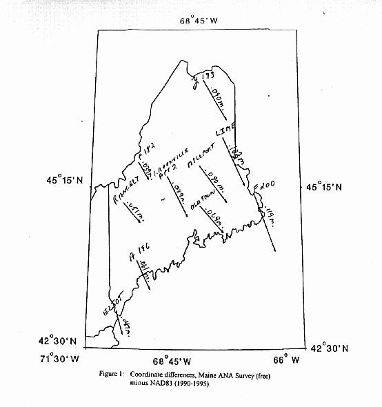
The first solid evidence of horizontal positional distortion in the HARN relative to the CORS was
discovered during the analysis of data from a B-Order survey in Maine (GPS1002, 1995). This project
tied several HARN stations to the CORS station "por2". In order to evaluate the published HARN
control relative to the CORS, a free adjustment of the data, using the position and ellipsoid height for
the CORS station "por2" as control, was performed. Positions from this adjustment were considered to
be the "best" positions, since they were determined using CORS control. A position shift comparison
was made between these "best" positions and the published HARN positions. Figure 1 illustrates these
shifts. The large magnitude of these shifts (up to 12-cm) was unexpected. It was imperative that the
root cause of such a large disparity between the CORS and HARN be found.
The cause of a network deficiency, such as this, can be isolated by following certain procedures.
First, the datasets which contribute to the portion of the network under study need to be identified.
The integrity of each contributing dataset must then be analyzed both independently and in conjunction
with each other. This is accomplished by analyzing the residuals of a free adjustment for each of the
independent datasets and then combining the datasets and analyzing the residuals of a free adjustment
of the combined dataset. Table 2 lists the A- and B-Order projects that were included in this analysis:
The Northeast HARN A- and B-Order (GPS394, 1992)
The Maine Area Navigation Approach (ANA) B-Order survey (GPS1002, 1995)
The Bangor Wide Area Augmentation System (WAAS) site A-Order survey (GPS744, 1994)
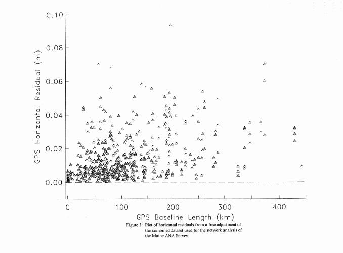
In this particular case, a residual analysis of the free adjustment of the combined dataset verified
that data from the Maine ANA Survey (GPS1002, 1995) were consistent with data from the Northeast
HARN (GPS394, 1992) and the Bangor WAAS site survey (GPS744, 1994) in the horizontal
component. See Figure 2 for a residual plot of this adjustment. The only outlier (9-cm) was an
observation from the Northeast HARN between the stations COWAN and TICONDEROGA. This
misfit only became evident when the data were combined. This observation was rejected. The
magnitude of the other horizontal residuals were at acceptable levels (7-cm or less). The compatibility
of data from these datasets made it unlikely that the positional distortion between the HARN and
CORS was caused by observational error in any of these datasets. Instead, this analysis of our best
and most recent data pointed to a problem in the published coordinates.
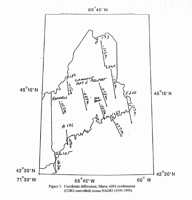
The next step in the analysis focused on an investigation of the control that was originally used to
determine the positions for the Northeast HARN (1992). The positions from the Northeast HARN
common to the ANA survey were originally determined by holding the A-Order positions for LIME
and K 169 from the original Eastern Strain Network (GPS421, 1987 and 1990). The combined dataset
included ties to two CORS stations. The Bangor WAAS site survey tied to the CORS station "wes2",
and the Maine ANA survey tied to "por2". By performing a test constrained adjustment, using the
coordinates for these two CORS stations as control, it was possible to obtain an optimal solution of
positions that were compared to the published positions from the original HARN. Figure 3 illustrates
these comparisons. There is a large discrepancy between the Eastern Strain positions for both LIME
and K 169 and their positions as determined in the more rigorous solution using CORS control. This
evidence supported the conclusion that the positional distortion found in Maine between the HARN and
CORS was caused by the observations or methods used in the data acquisition or data reduction of the
original Eastern Strain Network.
Analysis of the North Carolina/South Carolina HARN:
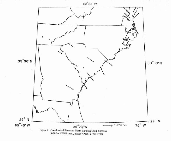
Data from the North Carolina/South Carolina A-Order HARN survey (GPS852, 1995) provided
more evidence of positional discrepancies in the HARN. This project tied several HARN stations to
the CORS station, "gait". In order to evaluate the published HARN control relative to the CORS, a
free adjustment of the data, using the position and ellipsoid height for "gait" as control, was performed.
A position shift comparison between the positions from this adjustment and the published HARN
positions was made. Figure 4 illustrates these shifts. While the magnitude of these shifts was small (2
to 5 cm), the directional differences between the previously determined HARN positions from Georgia
and South Carolina versus those from North Carolina and Virginia translated into a 5 to 8 cm
positional discrepancy among different HARN coordinates.
Table 3 lists the A-Order projects that were identified as being pertinent to the network analysis of
this problem:
The North Carolina/South Carolina HARN A-Order (GPS852, 1995)
The District of Columbia HARN (GPS396, 1992)
The Virginia HARN (GPS610, 1993)
The Georgia HARN (GPS721, 1994)
The Florida WAAS site survey (GPS855, 1995)
The Cape Canaveral United States Coast Guard (USCG) site survey (GPS861, 1995)
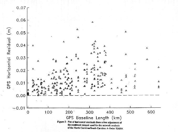
Free adjustments were run on each of the datasets and on the combined dataset. See Figure 5 for
a residual plot of the free adjustment of the combined dataset. This verified that data from these
datasets are compatible in the horizontal component.
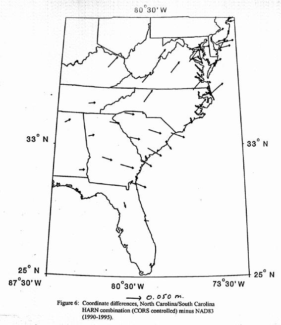
The combined dataset includes ties to two CORS stations. The North Carolina/South Carolina
HARN tied to "gait" and both the Florida WAAS site survey and the Cape Canaveral USCG site
survey tied to "rcm5". By performing a test constrained adjustment, using coordinates for these two
CORS stations as control, it was possible to obtain an optimal solution of positions that were compared
to the published HARN positions. Figure 6 illustrates these comparisons. Published positions from
Georgia and South Carolina shift 3 to 6 cm in a southeasterly direction relative to the CORS solution,
while published positions from Virginia and North Carolina shift 4 to 6 cm in a northeasterly direction.
This translates into a 5 to 8 cm discrepancy. Again, an analysis of the best and most recent data
pointed to a problem with the published coordinates.
The focus of the analysis shifted to an investigation of the control from the original Eastern Strain
Network (GPS421, 1987 and 1990) that was used to determine HARN positions in Virginia, North
Carolina, South Carolina and Georgia. An investigation of the constrained adjustments for the Georgia
HARN (GPS721,1994) and the Virginia HARN (GPS610,1993) projects revealed that the discrepancies
between the published positions from Georgia/South Carolina and Virginia/North Carolina were rooted
in the fixed control from the original Eastern Strain Network (GPS421, 1987 and 1990) used in their
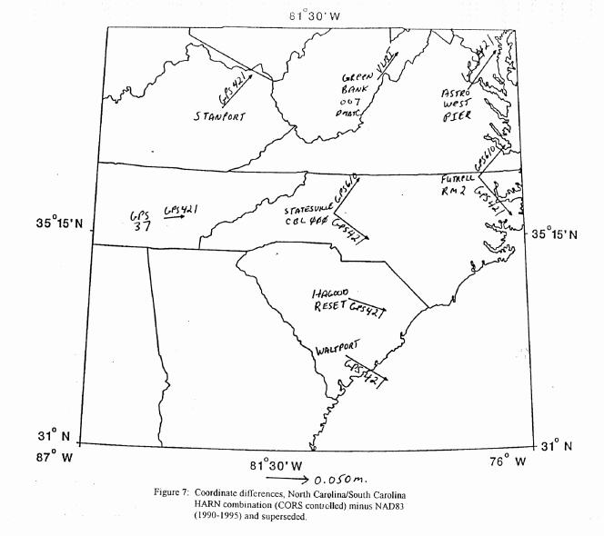
respective constrained adjustments. See Figure 7 for an illustration of how the fixed control from
GPS421 is shifting in relation to the CORS.
The Virginia HARN (GPS610, 1993) held the published positions for STANPORT, GREEN
BANK 007 DMATC, and ASTRO WEST PIER. The positions for STATESVILLE CBL 000 and
FUTRELL RM 2 were redetermined in this project. The Georgia HARN (GPS721, 1994) held the
published positions for HAGOOD RESET and WALTPORT but did not tie into the Virginia HARN.
The pair of shifts in Figure 7 at STATESVILLE CBL 000 and FUTRELL RM 2 illustrate how the
best solution (constraining only CORS control) compares to these station's redetermined positions
(Virginia HARN) and their superseded positions (Eastern Strain) respectively. Neither shift is
consistent with the optimal solution (CORS controlled). The shift from the Virginia HARN (GPS610,
1993) is consistent with the three positions from the Eastern Strain Network (STANPORT, GREEN
BANK 007 DMATC, and ASTRO WEST PIER) that were held in the Virginia HARN, but
inconsistent with the two positions from the Eastern Strain Network (HAGOOD RESET and
WALTPORT) that were held in the Georgia HARN. On the other hand, the shift from the superseded
positions from GPS421 for STATESVILLE CBL 000 and FUTRELL RM 2 are consistent with the
Eastern Strain positions for HAGOOD RESET and WALTPORT but not with the Eastern Strain
positions for STANPORT, GREEN BANK 007 DMATC, and ASTRO WEST PIER. This shows that
there is positional distortion in the Eastern Strain Network.
The piecemeal method of performing constrained adjustments of our HARN's was responsible for
the discontinuity between the Virginia HARN and the Georgia HARN that we have discovered. It was
only when the latest data from the North Carolina/South Carolina HARN became available that there
was enough connective HARN data available to isolate this problem. This lack of common control
stations between the Virginia and Georgia HARN's caused the discrepancy between the published
Eastern Strain positions for HAGOOD RESET and WALTPORT, and the redetermined positions from
the Virginia HARN for STATESVILLE CBL 000 and FUTRELL RM 2, to go undetected. Now that
the North Carolina/South Carolina HARN connects the Georgia HARN to the Virginia HARN the
discrepancy has become evident.
Since there were no direct ties to CORS stations in either the Virginia HARN or the Georgia
HARN, no comparisons with the CORS were made at the time of their adjustments. While a slight
horizontal offset (3-cm or so) between the CORS coordinates and the HARN coordinates was expected,
it was assumed that the direction and magnitude would be consistent throughout the A-Order network.
This was clearly not the case in this area (see Figure 6.)
INITIAL APPRAISAL OF THE NEW EASTERN STRAIN NETWORK PROJECT RELATIVE TO THE CORS
These early studies provided strong evidence of positional distortion in the Eastern Strain Network
project (GPS421, 1987 and 1990). Since this project served as the foundation of horizontal control for
the HARN, it became imperative that NGS determine the level of positional discrepancies between the
HARN and CORS throughout the country. In order to perform this study, more observational ties
between the CORS and HARN were required.
Fortunately, a nationwide re-observation of the Eastern Strain Network (GPS1008, 1996) provided
the data required to perform a thorough analysis of the HARN relative to the CORS. This survey was
observed to A-Order accuracy specifications, and provided many observational ties between HARN and
CORS stations.
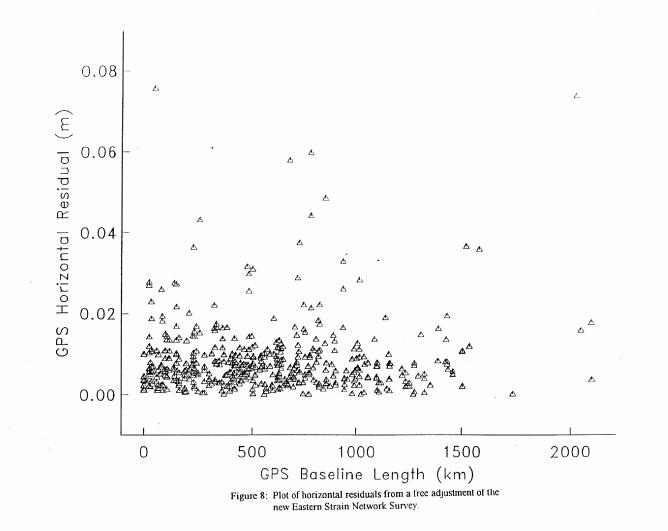
A free adjustment of the new Eastern Strain Network (GPS1008, 1996) was run to verify the
internal consistency of the data from this project. Figure 8 illustrates the horizontal residual plot from
this adjustment. The station ANGEL has the largest residuals in the horizontal component
(approximately 7.5-cm). No observational or data reduction error could be found. Since ANGEL was
located in Puerto Rico, these observations have virtually no effect on this study of the conterminous
United States. The magnitude of all other horizontal residuals were at acceptable levels (under 6-cm).
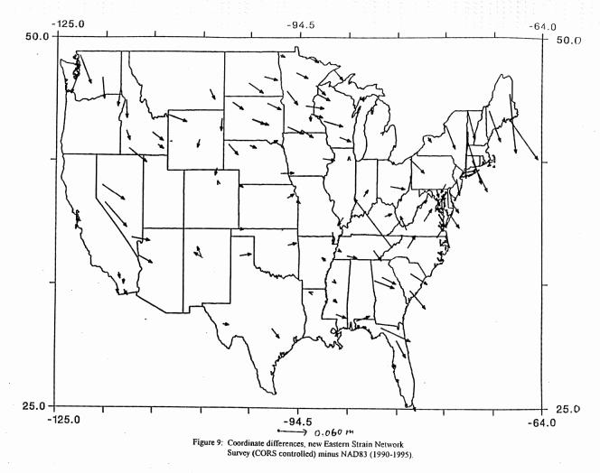
The following fifteen CORS stations participated in the new Eastern Strain Network project
(GPS1008, 1996): cha1, eky1, gait, vic1, hbrk, sag1, mnp1, vcap, mdo1, pie1, prco, tmgo, pbl1, rpt1,
and quin. In order to evaluate the status of the HARN relative to the CORS, a test constrained
adjustment of data from GPS1008, using the Epoch 1996.0 coordinates for the CORS stations as
control, was run. The positions from this adjustment (CORS controlled) were compared to the
published HARN positions. Figure 9 illustrates these comparisons.
An examination of the northeastern segment of the country confirmed that the magnitude of
positional discrepancy in Maine was large (10-cm level). In addition, it can now be seen that these
large shifts were not exclusive to Maine, but that they can also be found in the other New England
states as well.
In the southeastern segment of the country, the directional discrepancy between the positional
shifts from South Carolina and Georgia versus those from North Carolina and Virginia was also
confirmed. In addition, there is an unusually large shift (14-cm) at a HARN station located near the
North Carolina/Tennessee border. Another large shift (9-cm) can be seen at a HARN station located in
Florida.
In the northwestern segment of the country, the largest positional shifts were from the western
portion of the Nevada HARN. The two published B-Order positions from this area are shifting about
7-cm relative to the CORS. The next largest shift is seen at a B-Order station from the Washington
HARN. This station's published position is shifting 6-cm relative to the CORS.
In the southwestern segment of the country, all positional shifts between the HARN and CORS
are smaller than 5.5-cm.
The data from the new Eastern Strain Network (GPS1008, 1996) has enabled us to identify the
geographic areas throughout the conterminous United States where large (greater than 6-cm) positional
discrepancies exist in the HARN. These areas required a more thorough analysis. In some cases area
readjustments of the HARN data, to redetermine HARN coordinates, were necessary in order to resolve
these large discrepancies between the HARN and CORS coordinates.
AREA READJUSTMENT ANALYSIS OF THE HIGH ACCURACY REFERENCE NETWORK
Now that the levels of positional distortion in the HARN have been determined throughout the conterminous United States, it was possible to decide which areas of the HARN required the readjustment of positions. Any such action must include a thorough analysis of all A- and B-Order projects in the area. To simplify the effort, the new Eastern Strain Network Project (GPS1008, 1996) was divided into the following four sections: Southeast, Northeast, Southwest, and Northwest. Each section was analyzed separately. Since the internal consistency of the data from the entire Eastern Strain Network has been verified by means of an analysis of residuals from a free adjustment of the dataset (see Figure 8), there was no need to run free adjustments on each of the sections separately. It was possible to start the readjustment analysis of each portion by comparing a set of optimal coordinates from an adjustment that was constrained solely by CORS control to the published HARN control. It was assumed that the CORS control is nearly perfect and that the coordinates from this adjustment will be the "best" possible positions currently attainable from the data.
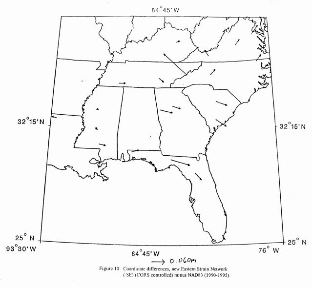
Southeast Portion:
A test constrained adjustment, using the CORS coordinates as control, was run. The following
CORS stations participated in this adjustment: cha1, eky1, gait, and vic1. This adjustment produced an
optimal set of coordinates that were compared to the published HARN positions. See Figure 10 for a
plot of these position shifts.
First, the large positional shift (14-cm) at the HARN station located near the North
Carolina/Tennessee border (see Figure 10) was investigated. In this case, the problem was easily
pinpointed. The station in question, MAX PATCH, had a published position that was determined in
the original Tennesse HARN (GPS120, 1990). Macrometers were used to establish the 1990
Tennessee HARN. Large observational errors were uncovered and most of the HARN was re-observed
in 1995 (GPS904). Most of the positions from the original HARN have been readjusted and re-published based solely on the 1995 data. MAX PATCH was one of the few stations that was not re-observed in 1995. Due to the questionable nature of its original determination, this position was
readjusted without further investigation.
Next, the large positional shift (9-cm) at the Florida HARN station, GINGER WETHERELL, was
investigated. The source of this position's determination was a 1993 project (GPS538) that re-observed
part of the Florida HARN. This was a newly established station in that project. While no problems
were detected at the time of the constrained adjustment of GPS538, there have been subsequent
reports from surveyors in Florida that there was a misfit between the position for GINGER
WETHERELL and other HARN positions in Florida. The problem at this station has since been
verified by an analysis of data from a B-Order ANA survey (GPS936, 1995). The current evidence
suggests that this is an isolated case, rather than a widespread problem throughout the Florida HARN.
Therefore, the position for GINGER WETHERELL was readjusted without further analysis.
Finally, the discontinuity between the HARN positions from Georgia/South Carolina versus those
from North Carolina/Virginia was confirmed (see Figure 10). At the time of this study, data from the
North Carolina/South Carolina HARN (GPS852, 1995) was available, but the constrained adjustment
had not yet been completed. A readjustment of positions from either the Virginia HARN (GPS610,
1993) or the Georgia HARN (GPS721, 1994) would be necessary in order to adequately fit the new
data from the North Carolina/South Carolina HARN into the network. An examination of the
constrained adjustments for the Kentucky HARN (GPS611, 1994) and the West Virginia HARN
(GPS908, 1995) confirmed that control from the Virginia HARN (GPS610, 1993) was used in these
adjustments. Any readjustment of positions from the Virginia HARN would require an in depth
analysis of the effect of such a readjustment on the Kentucky and West Virginia HARN's. In order to
maintain a consistent network across the area, the additional readjustment of HARN positions in
Kentucky and West Virginia might also be required. The impact of readjustment of positions from the
Georgia HARN (GPS721, 1994) would be much less severe. Only Georgia would be affected. The
decision was made to constrain the published positions from the Virginia HARN. Positions determined
in the A-Order portion of the Georgia HARN would be readjusted. Finally, a follow-up readjustment
analysis of the B-Order portion of the Georgia HARN would be performed.
Now that the areas of the HARN that require readjustment have been identified, the emphasis of
the analysis shifted to the performance of this task. Table 4 lists the projects that were included in this
analysis:
The North Carolina/South Carolina A-Order HARN (GPS852, 1995)
The Eastern Strain Network, A-Order, Southeast Portion (GPS1008, 1996)
The Georgia A-Order HARN (GPS721, 1994)
The Combahee River Basin, South Carolina A-Order (GPS516, 1992)
The Florida WAAS A-Order site survey (GPS855, 1995)
The Cape Canaveral USCG A-Order site survey (GPS861, 1995)
The Fort Macon USCG A-Order site survey (GPS949, 1995)
The Charleston USCG A-Order site survey (GPS950, 1995)
Two additional vectors between FLNRC 1 and FAA 53 A B supplied by an NGS field party.
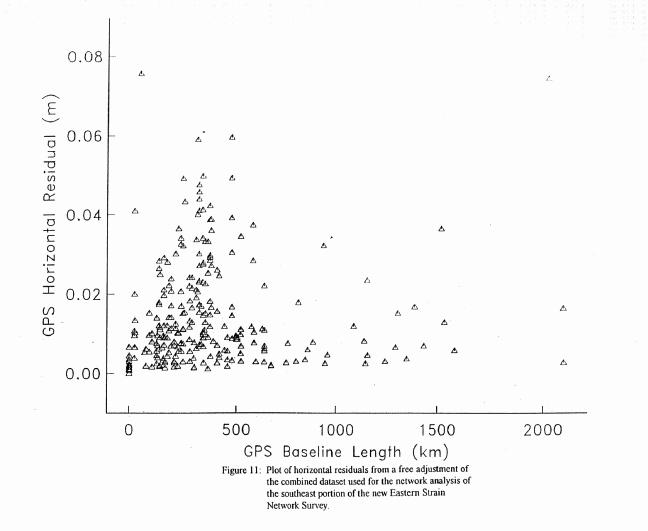
These projects were combined into a single dataset. In addition to the four CORS stations that
participated in the new Eastern Strain Network project (GPS1008, 1996), the combined dataset includes
ties to two more CORS stations (rcm5 and fmc2). A free adjustment of the combined dataset verified
that data from these datasets are compatible in the horizontal component. See Figure 11 for a residual
plot of this adjustment. The distribution of residuals is very similar to the stand-alone free adjustment
of the new Eastern Strain Network project (GPS1008, 1996) (see Figure 8).
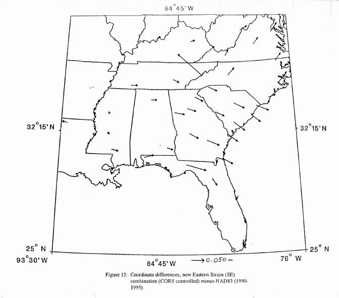
A test constrained adjustment, using the Epoch 1996.0 coordinates for the CORS stations as
control, was run. This adjustment produced an optimal set of positions which were compared to the
published HARN positions. See Figure 12 for a plot of these comparisons. The shifts seen here are
similar to those from the stand-alone adjustment (CORS coordinates held) of the new Eastern Strain
project (see Figure 10). By including these additional projects and CORS ties, the solution has been
strengthened and our previous analysis has been confirmed.
A final constrained adjustment was run on the combined dataset. This adjustment constrained the
coordinates for the CORS stations and many of the published HARN stations. The positions for most
of the HARN stations located in Georgia and South Carolina were readjusted. The newly determined
positions for these HARN stations were adopted by NGS and supersede the original HARN positions.
In addition, the positions for the two outliers, GINGER WETHERELL (Florida) and MAX PATCH
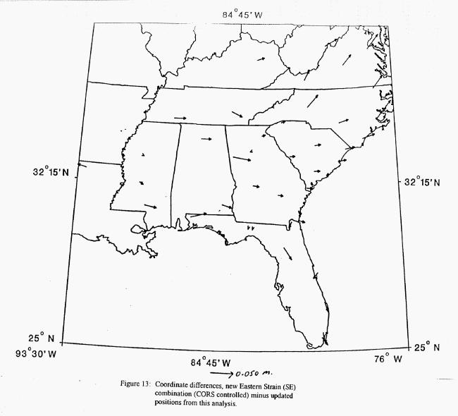
(North Carolina) were readjusted. Figure 13 illustrates the positional shift comparisons between the
optimal solution (constrained solely with CORS control) and the final constrained adjustment. In the
readjustment area (Georgia and South Carolina) the positions are now much more consistent with the
CORS. The only exception is at the station near the Georgia-Alabama boundary (CAROLLTON
NCMN 2). This station's position is still shifting 4.5-cm relative to the CORS. Since this station's
position has been heavily used by surveyors in Georgia, it was not readjusted in the final constrained
adjustment. In this case, convenience to the user community took precedence over technical issues. In
any case, constraining this position had only a negligible effect on the final solution.
The readjustments performed in this area have greatly improved the HARN network. There now
is greater agreement between the CORS and HARN in South Carolina and Georgia. In addition, the
discontinuity between the Georgia HARN and Virginia HARN has been greatly reduced. However, in
areas that were not readjusted, there remains a positional discontinuity of up to 6-cm between the
CORS and HARN.
The final stage of this readjustment analysis involved the performance of a study to determine if
there is a need for further readjustments of positions in the B-Order HARN in this geographic area.
The Georgia B-Order HARN is the only project that could be adversely affected by the readjustments
performed thus far. NGS is committed to maintaining length relative accuracy standards throughout
the HARN. By readjusting some of the A-Order control in the Georgia HARN without subsequently
readjusting the B-Order, discrepancies between the A- and B-Order positions will occur.
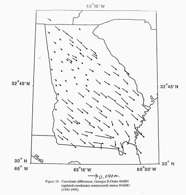
To determine the magnitude of these discrepancies, a test constrained adjustment was run using
data from the Georgia B-Order HARN (GPS721, 1994). In this adjustment, the readjusted positions
from the final constrained adjustment of the combined dataset were used as control. All B-Order
stations from the Georgia HARN were readjusted. Figure 14 illustrates the positional shifts between
this adjustment and the published B-Order control in the area. With the exception of N 178 (6.5-cm)
all shifts were 4-cm or less. Since the magnitudes of these shifts were small and they were consistent
with each other in a directional sense, it was hypothesized that only a minimal readjustment of
positions from the Georgia B-Order HARN would be necessary to maintain the length relative accuracy
standard in that state.
A test was performed to see if B-Order length relative accuracies (1:1,000,000) would be
maintained in the Georgia B-Order HARN with no further readjustment of positions. To accomplish
this, a test dataset of Georgia B-Order positions was constructed. Previously published positions from
the Georgia B-Order, that have now been readjusted, were replaced with the readjusted positions. The
rest of the positions were not changed. A free adjustment of the Georgia B-Order was run using the
test dataset of positions as input. Length relative accuracies were computed over all observed lines.
Only a handful (ten out of two hundred) did not meet the B-Order standard of 1:1,000,000.
In order to improve these accuracies, it was determined that positions for seven B-Order positions
from the Georgia HARN should be readjusted. A final constrained adjustment of the Georgia B-Order
HARN was run. Control for this adjustment consisted of both the readjusted positions from the A-Order final constrained adjustment and most (all but seven) of the published positions from the Georgia
B-Order HARN. A final free adjustment, using the output positions from this adjustment as input was
run. All accuracies from this adjustment met the B-Order standard of 1:1,000,000.
This completed the readjustment analysis for the southeastern portion of the United States. NGS's
integrated database has been updated to include the updated positions for the stations that have been
readjusted as a result of this analysis.
Northeast Portion:
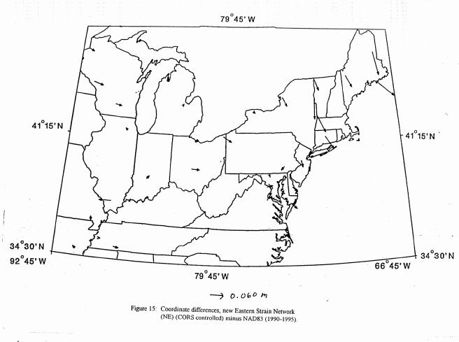
A test constrained adjustment, using the CORS coordinates as control, was run. The following
CORS stations participated in this adjustment: gait, hbrk, mnp1, sag1, and vcap. This adjustment
produced an optimal set of coordinates that were compared to the published HARN positions. See
Figure 15 for a plot of these position shifts.
The large discrepancy (5 to 11 cm) between the HARN and CORS in the New England states was
confirmed. Since there are numerous CORS sites in the New England states, it is anticipated that
surveyors from this area will begin to use CORS in conjunction with the HARN on a routine basis.
The large magnitude of distortion between the HARN and CORS is already being noticed by the
surveying community. For these reasons, the decision to perform a complete readjustment of HARN
positions in this area was made. All A- and B-Order positions for stations located in Maine, New
Hampshire, Vermont, Massachusetts, Connecticut, and the eastern half of New York would be
readjusted. Additionally, the HARN control in New Jersey would be readjusted. While the level of
discontinuity between the HARN and CORS is small in New Jersey (less than 4-cm), there are
surveyors in that community that are using CORS data in their surveys. In addition, the state
readjustment of New Jersey has not yet been completed. Since New Jersey has a large first order GPS
network with numerous ties to HARN stations, a strong case can be made for using the "best" HARN
positions as control for their state readjustment. The state advisor to New Jersey was consulted, and
the decision to readjust was made.
The readjustment of such a large area required a plan. In the southeast, all A-Order projects were
combined with the new Eastern Strain data and adjusted together. In this area, the Northeast HARN
(GPS394) was observed in 1992. While the data from this HARN is considered to be quite good in
the horizontal component there were reduction problems that produced error at the 15-cm level in the
vertical component. The primary purpose of this readjustment effort was to produce HARN positions
that are more consistent with the CORS. However, ellipsoid heights were also redetermined. To avoid
the possibility of having the observations from the original HARN contaminate the results from this
readjustment in the height component, the 1992 data from the northeast HARN were excluded from the
top level of this analysis. Instead, a three-layered approach to the readjustment effort was taken. The
top layer consisted of data from the new Eastern Strain Network (GPS1008, 1996) plus data from all
recent A-Order surveys in the area. The second layer consisted of the A-Order portions of the
Northeast HARN (GPS394, 1992) and the District of Columbia HARN (GPS396, 1992). The final
layer consisted of all B-Order projects in the area. Ellipsoid heights were re-determined for every
station whose position was readjusted. Positions and ellipsoid heights that were re-determined in the
top layer were constrained in the second layer and positions and ellipsoid heights re-determined in the
top two layers were constrained in the third layer. By this procedure, we insured that the most
consistent set of positions and ellipsoid heights were produced, given the current data.
Table 5 lists the A-Order projects that were combined into a single dataset for the top layer of this
analysis:
The Eastern Strain Network, Northeast portion (GPS1008, 1996)
The Bangor WAAS site survey (GPS744, 1994)
The New York WAAS site survey (GPS744/B, 1994)
The Atlantic City WAAS site survey (GPS744/D, 1994)
The Boston WAAS site survey (GPS744/F, 1994)
The Montauk Point USCG site survey (GPS744/K, 1994)
The Chatham and Portsmouth USCG DGPS site survey (GPS744/L, 1994)
The Sandy Hook USCG site survey (GPS744/M, 1994)
The Brunswick USCG site survey (GPS879, 1995)
The Youngstown USCG site survey (GPS880, 1995)
The Ohio HARN (GPS882, 1995)
The Cape Henlopen USCG site survey (GPS942, 1995)
The Sandy Hook USCG site survey (GPS943, 1995)
The Montauk Point USCG site survey (GPS944, 1995)
The Chatham USCG site survey (GPS945, 1995)
The Portsmouth USCG site survey (GPS946, 1995)
The Brunswick USCG site survey (GPS947, 1995)
The Detroit USCG site survey (GPS1023, 1996)
The Youngstown USCG site survey (GPS1024, 1996)
The New Brunswick Cooperative GPS survey (GPS1198, 1996).
The combined dataset included ties to the following CORS stations: bru1, chl1, cht1, det1, gait,
hbrk, mnp1, por2, sag1, shk1, stl2, wes2, vcap, and you1. A free adjustment of the combined dataset
verified that data from these projects are compatible in the horizontal component. See Figure 16 for a
residual plot of this adjustment. All horizontal residuals are under 5-cm.
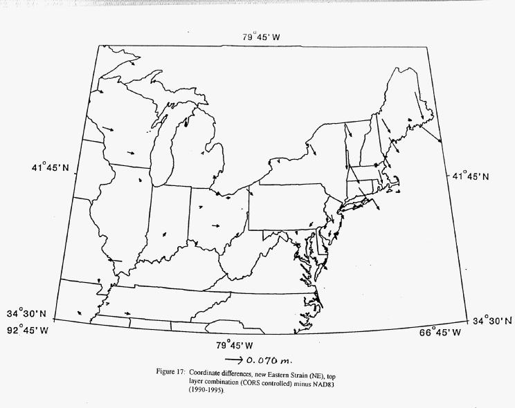
A test constrained adjustment, using the Epoch 1996.0 coordinates for the CORS stations as
control, was run to produce an optimal set of coordinates. Figure 17 illustrates the differences between
these coordinates and the published HARN positions. The large positional shifts seen here confirmed
that there was a need for a massive readjustment of the New England area. Elsewhere, positional distortion between
the HARN and CORS is small (5.5-cm or less).
A final constrained adjustment was run on the combined dataset. In addition to the coordinates for
the CORS stations, this adjustment constrained all published positions for HARN stations located
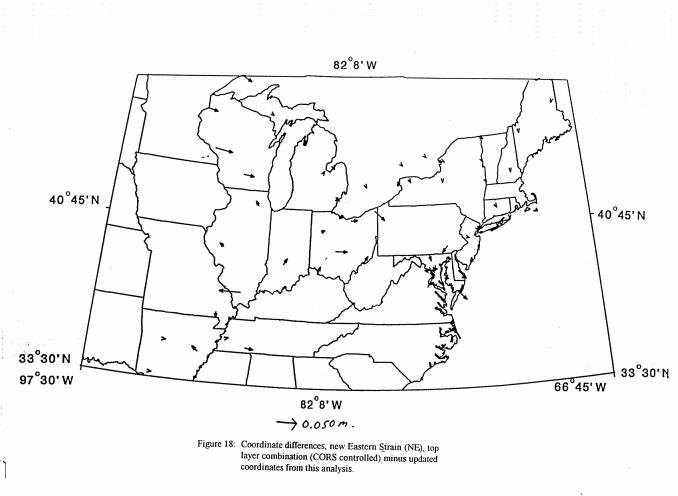
outside the area to be readjusted. Figure 18 illustrates the positional shift comparisons between the
optimal solution (constrained solely with CORS control) and the final constrained adjustment.
The large magnitude of distortion between the CORS and HARN positions participating in this
dataset has now been reduced to an insignificant level in the New England area. To complete the
analysis, a readjustment of the rest of the published HARN control in this area would be performed.
In the next phase of this effort, data from the A-Order portions of the Northeast HARN (GPS394,
1992) and the District of Columbia HARN (GPS396, 1992) were combined into a single dataset. A
free adjustment of the combined dataset verified that the data from these projects are compatible in the
horizontal component. See Figure 19 for a residual plot of this adjustment. All horizontal residuals
are under 5.5-cm.
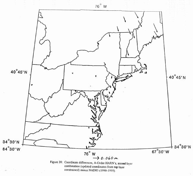
To determine the level of discontinuity between the readjusted A-Order positions from the top
layer and the remaining A-Order HARN positions in the area, a test constrained adjustment was run.
This adjustment used the readjusted positions from the top layer as control. Figure 20 illustrates the
positional differences between this adjustment and the published HARN control in the area. Position
shifts in the New England area range from 5 to 10 cm.
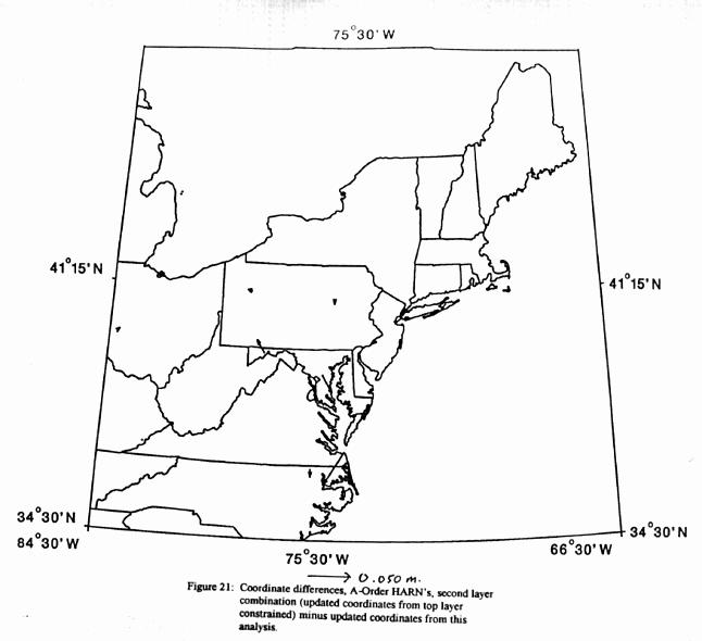
A final constrained adjustment was run on the A-Order dataset. In addition to the readjusted
positions from the top layer, this adjustment constrained the positions for the HARN stations located
outside the readjustment region. The extra HARN positions constrained in this adjustment had very
little effect on the final solution. Figure 21 illustrates the position shifts between the test constrained
adjustment of the A-Order dataset and the final readjusted positions. Where positional shifts are 0.000
m., no shift is shown. In the New England states and New Jersey where positions have been
readjusted, the resulting positions from the test constrained adjustment are identical to those from the
final constrained adjustment.
This readjustment of the A-Order HARN in New England and New Jersey made the network more
consistent with the CORS in that region. The final step in this analysis would be to perform a similar
readjustment of the B-Order data.
Table 6 lists the B-Order projects that were combined into a single dataset for the third layer of
this analysis:
The Atlantic City Federal Aviation Administration (FAA) survey (GPS369, 1991)
The Northeast HARN (GPS394, 1992)
The Cooperative Base Network, New York survey (GPS881, 1994)
The Cooperative Base Network II, New York survey (GPS997, 1995)
The MS 23 RESET HARN re-observation survey (GPS996, 1995)
The Maine ANA survey (GPS1002, 1995)
A free adjustment of the combined dataset verified that the data from these projects are compatible
in the horizontal component. See Figure 22 for a residual plot of this adjustment. All horizontal
residuals are under 5-cm.
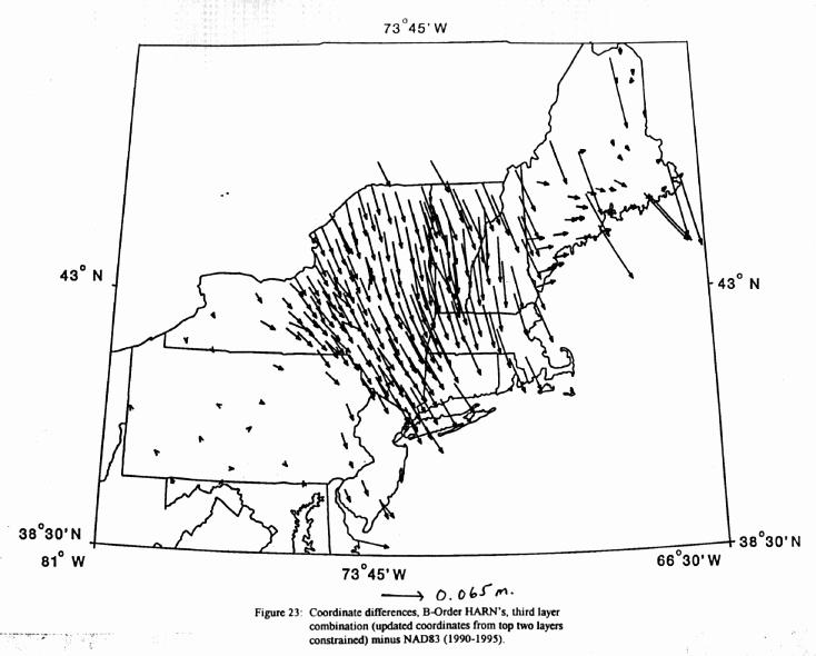
To determine the level of discontinuity between the A-Order positions that have been readjusted
thus far and the published B-Order positions in the area, a test constrained adjustment was run. In
addition to the coordinates for the CORS station "por2", this adjustment constrained the readjusted
positions from the top two layers of this analysis. Figure 23 illustrates the positions shifts between this
adjustment and the published B-Order control in the area. In general, the magnitude of discontinuity is
at the 5 to 10 cm level in New England and eastern New York. A number of stations with small
differences can be found in Maine. These are from positions determined in the Maine ANA survey
(GPS1002, 1995). Since the distortion between the HARN and CORS in Maine was detected before
the constrained adjustment of the Maine ANA survey, the coordinates from the HARN were not
constrained in that project. Instead, positions were determined solely by constraining the coordinates
for the CORS station "por2". Since only CORS control was used in the Maine ANA survey's
constrained adjustment, it is not surprising that there was close agreement (less than 3-cm) between the
published positions from it and those from this adjustment.
A final constrained adjustment was run on the B-Order dataset. This adjustment added the
coordinates for the HARN stations located outside the readjustment region as control. The positions
resulting from this adjustment were similar to those from the test constrained adjustment in the New
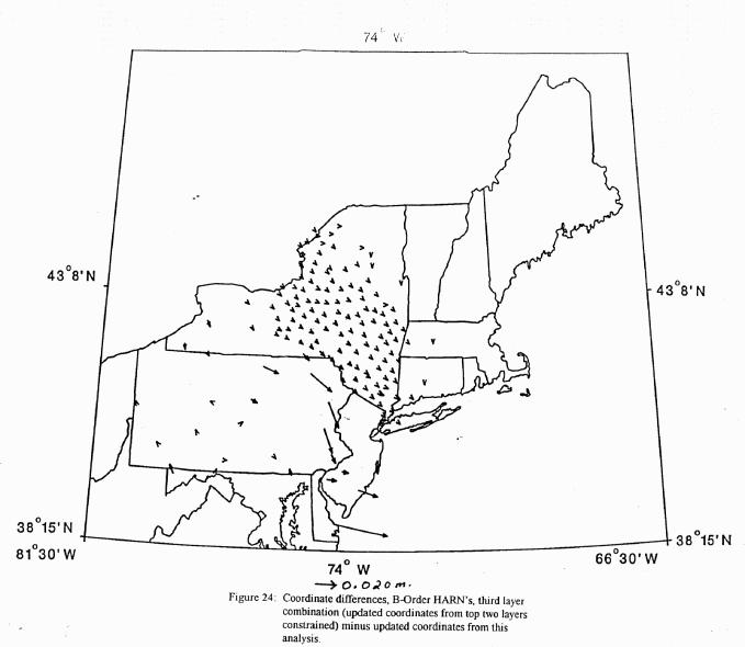
England area. Figure 24 illustrates these differences. All positional shifts between the test constrained
adjustment (only coordinates from the top two layers held) and the final constrained adjustment were
under 1-cm in the New York and New England area.
The readjustment of HARN coordinates in the northeast has now been completed and NGS's
integrated database has been updated to reflect these changes. Surveyors should no longer experience
large (greater than 5-cm) positional distortion between the HARN and CORS network in this region.
The best fit will occur in the readjustment region of New York, New Jersey, and New England. In
areas outside of the readjustment region, such as Wisconsin and Minnesota, positional discrepancies
between the HARN and CORS will be larger (up to 5-cm).
Northwest Portion:
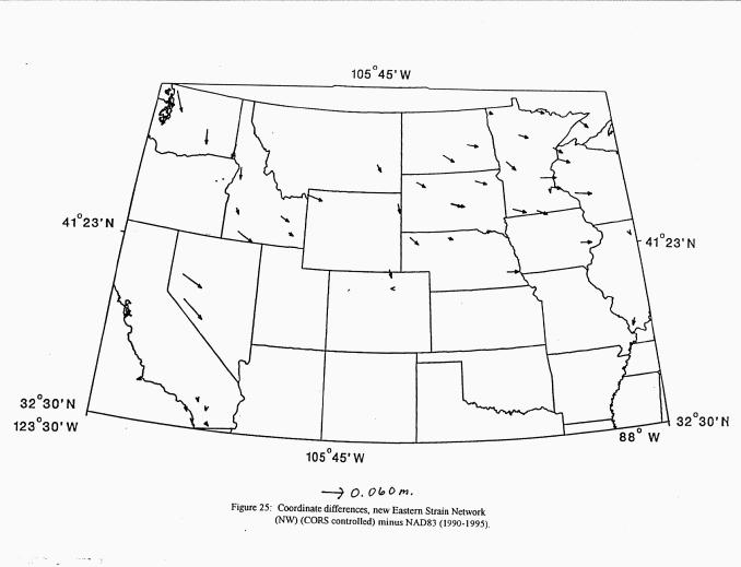
A test constrained adjustment, using the CORS coordinates as control, was run. The following
CORS stations participated in this adjustment: hbrk, pbl1, quin, rpt1, and tmgo. This adjustment
yielded an optimal set of coordinates that were compared to the published HARN positions. See
Figure 25 for a plot of these position shifts.
There are two large shifts (7.6-cm and 6.7-cm respectively) at the stations H 231 and FLAT.
These stations were originally determined in the B-Order portion of the Nevada HARN (GPS404,
1994). An examination of the constrained adjustments of both the A- and B-Order portions of this
project revealed that several positions from the California HARN (GPS412, 1991) were constrained to
their published epoch 1991.35 values in these adjustments. Although these stations were not located in
an earthquake region, it was hypothesized that crustal movement at these stations between 1991 and
1994 could explain the positional discrepancies found here. Analysis of VLBI data from Nevada, in the Sierra Nevada Mountains and eastward, verify crustal movement to be at the order of 1 cm per year.
To test this hypothesis, several test constrained adjustments were run. First, a constrained
adjustment of the A-Order portion of the Nevada HARN was run. This adjustment duplicated the
original constrained adjustment performed in 1995, with the exception that the California positional
constraints were converted from the 1991.35 epoch to the 1994.55 epoch using the crustal motion
software program HTDP. Similarly, a constrained adjustment of the Nevada B-Order HARN was run.
This adjustment was similar to the 1995 constrained adjustment except that the control from California
was updated to the 1994.55 epoch and the control from the A-Order portion came from the test
constrained adjustment described here. The positions for H 213 and FLAT from this adjustment were
then compared to the optimal adjustment (CORS constrained) of the Eastern Strain Network/Northwest
portion. The positional differences improved from 7.6-cm at H 213 to 4.7-cm and from 6.7-cm at
FLAT to 4.1-cm. This provides strong evidence that the positional constraints from California used in
the Nevada HARN should have been converted to the 1994.55 epoch at the time of its adjustment.
The remaining 4 to 5 cm discrepancy in Nevada could be caused in part by unmodeled crustal
movement in Nevada between 1994 and the time of the Eastern Strain Network (May, 1996).
Again, NGS was faced with a decision to either readjust the Nevada HARN based on this analysis
or to leave the positional distortion at its current level for the time being. To date, there have been no
complaints from surveyors in Nevada about the apparent HARN/CORS misfit there. From this, it is
inferred that the user community in Nevada is satisfied with the current status of the HARN.
Therefore, there is no immediate need to readjust the HARN in this area. After the completion of the
HARN surveys, a national readjustment of the HARN network has been proposed. If implemented,
this will greatly reduce the level of positional distortion found in the HARN in Nevada and throughout
the country. For these reasons, no readjustment of positions was performed at this time.
Another large shift (6-cm) can be found at a B-Order HARN station from Washington State named
GP 37009 1 RESET. In general, the shifts are in the 4 to 6 cm range throughout Washington. Since
the time of the constrained adjustment of the Washington B-Order HARN, an error in the GPS
reductions has been detected. This error introduced a scale bias into the dataset. Before any
readjustment of this HARN is performed, the data should be re-reduced to correct this problem. Since
this has not yet been done, a readjustment of the Washington HARN was not seriously considered at
this time.
Since the time of this analysis, B-Order data from the Washington ANA project (GPS1196, 1996)
has become available. This dataset includes ties to the following three CORS stations: rpt1, whd1, and
fts1. An independent analysis of this dataset confirmed that there are shifts between 2 and 7 cm
between the CORS and HARN throughout the state of Washington. Figure 26
illustrates the positional
differences between an adjustment constrained by CORS control and the published HARN positions in
this region. In this case, NGS was faced with a particularly difficult situation. By contractual
agreement with the FAA, NGS must provide positions from ANA projects that are consistent with the
CORS to within 5-cm. Three of the sixteen HARN positions exceeded this level in Washington state.
To resolve this problem, NGS has provided coordinates from the optimal solution to the FAA to meet
their requirements. However, since a readjustment of the HARN was not performed, these coordinates
are not consistent with current HARN coordinates. Therefore, the original HARN positions of stations
that participated in this survey were not superseded by this adjustment.
This situation in Washington exemplifies some of the problems that NGS faces in maintaining a
consistent set of HARN positions that are accurate at the 5-cm level or better. The NGS, integrated database now contains
several types of A- and B-Order control points. First, there are the CORS positions themselves.
Second, there are positions that have been determined in surveys that solely use coordinates from the
CORS as control. Third, there are positions that have been determined in projects that use a
combination of CORS and older HARN control. Lastly, there are positions determined with no CORS
control. High order surveys can now detect positional discrepancies between the various types of
control. A nationwide readjustment of the HARN's would greatly reduce these network deficiencies.
The readjustment analysis of the northwest region has now been completed. For the time being,
no readjustment of HARN positions will be made. The positions of new stations from this project
were determined by using a mixture of CORS and older HARN control.
Southwest Portion:
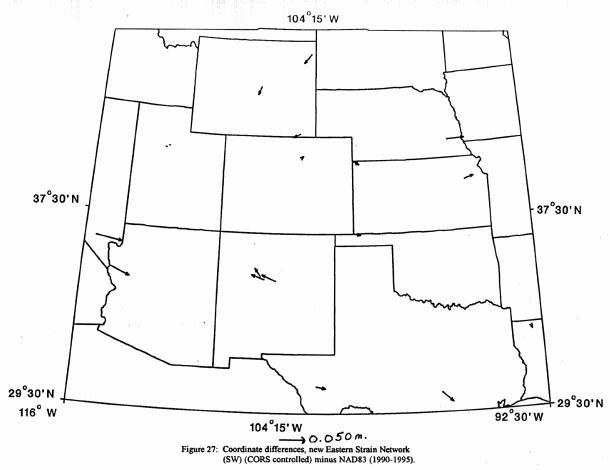
A test constrained adjustment, using the CORS coordinates as control, was run. The following
CORS stations participated in this adjustment: hbrk, mdo1, pie1, and prco. This adjustment produced
an optimal set of coordinates that were compared to the published HARN positions. Figure 27
illustrates these position comparisons.
All position shifts were smaller than 5.5-cm. Since the HARN is consistent with the CORS at this
level, no readjustment of HARN positions were performed in this area. The positions of new stations
from this project were determined using a mixture of CORS and older HARN control.
With the completion of the readjustment analysis of each portion of the country, a nationwide
evaluation of the HARN relative to the CORS was possible. To accomplish this, a combined dataset
consisting of all data from the new Eastern Strain Network project (GPS1008, 1996) and all projects
that participated in the top layer of the readjustment analysis from the southeast and northeast portions
was created. A free adjustment verified that these datasets were compatible in the horizontal
component. See Figure 28 for a residual plot of this adjustment.
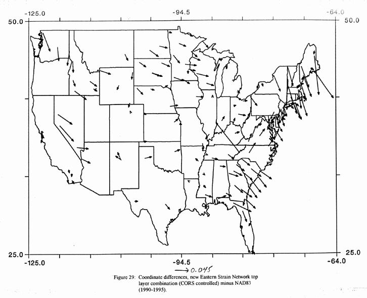
An optimal solution of positions was produced from a test adjustment that constrained the
coordinates for all CORS stations participating in this study. The success of the readjustment process
can be evaluated by comparing these improved positions with both the original published HARN
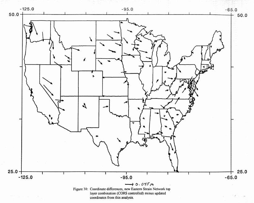
positions and the currently published (readjusted) positions. Figures 29 and 30 illustrate these
respective comparisons. In the northeast and southeast, the readjusted positions are significantly closer
to those from the more rigorous solution (CORS controlled). In areas outside the readjustment region,
the fit between the HARN and CORS network remains the same. The attached table is provided to allow each reader to see how well their state HARN currently fits with the CORS network.
It has been shown that there is positional distortion in the HARN relative to the CORS. In the
northeast and southeast, the problem was isolated to the control from the original Eastern Strain
Network used to determine these HARN positions. It should be noted that the methods used to isolate
this problem did not require the inclusion of the original Eastern Strain Network data itself. For the
purposes of this analysis, it was enough to know that these data were suspect. As a side note, Richard
Snay (geodesist at NGS) was performing crustal motion research concurrently with this analysis (Snay,et.al.,
1997). In his analysis, the original Eastern Strain Network data was analyzed relative to the HARN
data and the new Eastern Strain Network data. He also discovered problems in the northeast and
southeast. The original Eastern Strain data has now been re-reduced and some errors in the original
reductions were discovered and have now been corrected.
In the paper "The Trouble with Constrained Adjustments" (Schwarz, 1994), the problem of
degrading a good survey through the use of inferior constraints is discussed in great detail. While the
whole purpose of creating the HARN was to create a framework of reliable coordinates, we now find
that even these coordinates have been flawed by the constraints used in their determinations.
Fortunately, there is not a widespread problem with the HARN data itself. With an improved set
of constraints, network deficiencies such as this, can be easily resolved through the readjustment of
positions. The CORS coordinates provide the necessary control.
To attain the best possible positions, a complete readjustment of the HARN network to the CORS
constraints would be most desirable. In the meantime, decisions to readjust certain portions of the
HARN are made. These decisions are currently based on an assessment of the current level of
positional distortion found in a given area and the perceived needs of the user community in these
areas.
It is NGS's responsibility to maintain a HARN that meets the needs of the user community.
Pending public acceptance, the NGS Executive Steering Committee has approved the recommendation
of the Readjustment Options Team (Vorhauer et. al., 1996) to perform a nationwide readjustment of the
HARN, using the CORS as control. This readjustment would largely reduce the levels of positional
distortion found in the current network. The current challenge to NGS is to balance the immediate
need to improve certain portions of the network with area readjustments, with the inconvenience caused
to the user community by publishing readjusted coordinates.
As the user community becomes more adept at using CORS data in conjunction with their surveys,
there will be an increased demand for HARN coordinates that are more and more consistent with the
CORS. This analysis has generally used a disparity of 6-cm between the CORS and HARN as the
breakoff point for area readjustments to take place. It is envisioned that there will soon be a demand
for agreement at the 3 to 4 cm level. It seems logical that a readjustment of the entire HARN would
be preferable to the continual upsetting of coordinates through small area readjustments in response to
user demand.
It should also be noted that this analysis solely examines HARN horizontal positions relative to the
CORS. Thus far, there has not been an extensive study of how well the ellipsoidal heights from the
HARN fit the CORS heights. Preliminary results indicate that this is a much more complicated
problem. A network of consistent ellipsoid heights is required to improve the geoid model and
ultimately to improve the accuracy level of orthometric heights derived from GPS. NGS's current 18
month effort to re-observe a significant portion of the A-Order HARN with specifications designed to
attain 2-cm ellipsoid heights should provide the necessary data for an extensive analysis of the network
of ellipsoid heights. This is clearly an area in need of future study.
The availability of data from the new Eastern Strain Network project in conjunction with the
CORS network has enabled NGS to evaluate HARN coordinates relative to CORS coordinates
nationwide. Positional distortion in the HARN coordinates at the 6 to 12 cm level has been found in
Nevada, New England and in the southeastern portion of the United States.
In New England and the southeast, the network deficiency was traced to the constraints from the
old Eastern Strain Network that were used as control for these HARN's. In Nevada, the network
deficiency was traced to the 1991.35 Epoch positions from California that were constrained in the
Nevada HARN. These positions should have been converted to the 1994 epoch prior to the
constrained adjustment of Nevada.
In all of these cases, the cause of the network deficiency was isolated to the control used to
determine the HARN positions rather than from the HARN data. With improved control, a
readjustment of positions can be performed to correct the problem. CORS coordinates provide this
control.
In New England, where positional distortion was largest (up to 12-cm), a complete readjustment of
HARN positions was performed. HARN positions from this area of the country should now be
consistent with CORS positions.
In the southeast, most A-Order HARN positions from Georgia and North Carolina were readjusted
to smooth out the inconsistencies between the Georgia HARN and the Virginia HARN. A subsequent
readjustment of a few B-Order stations in Georgia was performed to maintain B-Order length relative
accuracies across that state.
In Nevada, no readjustment of positions were performed at this time. The HARN/CORS disparity
of 6 to 8 cm in western Nevada remains. In this case, the inconvenience caused to the user community
by a massive change in coordinates outweighs the slight improvement that would result from a
readjustment of positions.
In other parts of the country, the positional discrepancy between the HARN and CORS is less than
6-cm. This magnitude of distortion is considered acceptable at this time.
In conclusion, this study has addressed all currently known, large positional discrepancies in the
HARN network. However, there are many new high order surveys with connections between the
CORS and HARN that have been submitted to NGS since this study. Data from more of these surveys
will become available in the near future. There may still be some undiscovered areas of the HARN
where network deficiencies exist. Analysis of the HARN relative to the CORS will continue on a
project by project basis as new data becomes available. Additionally, this study was limited to the
conterminous United States. The availability of more connective data between HARN and CORS sites
in Alaska, Hawaii and the Carribean will allow us to evaluate the HARN relative to the CORS in these
areas.
The results of this analysis and readjustment effort indicate that the HARN positions throughout
the conterminous United States are generally in agreement with the CORS to within 6-cm. By
contrast, accuracies of 1 to 2 cm are obtained for CORS positions. While a 6-cm agreement is
currently acceptable for most applications, the increased use of CORS data and control in conjunction
with HARN control for user surveys will inevitably increase the demand for better agreement between
the CORS and HARN. To obtain the best possible agreement between HARN positions and CORS
positions, it is recommended that a nationwide readjustment of the HARN's be performed, using the
CORS positions as control.
In addition, a study has not yet been performed to determine how well the ellipsoid heights from
the HARN agree with the CORS coordinates. In order to attain the best coordinates in three
dimensions, it is recommended that such as study be performed.
The author thanks the following persons from NGS for their support in this analysis: Edward Carlson, Richard Foote, Lucy Hall, Dennis Milbert, Richard Snay, Tom Soler, William Strange, and Maralyn Vorhauer.
Cheeves, Marc. 1997. "CORS Update." Professional Surveyor, March 1997, pp. 34-35.
Schwarz, C.R. 1994. "The Trouble with Constrained Adjustments," Surveying and Land Information Systems, vol.54, no. 4, pp. 202-209.
Snay, R.A., W. E. Strange, and E. G. Zurflueh., 1997. "Horizontal Velocities in the Central and Eastern United States from GPS Surveys during the 1987-1996 Interval". NUREG/CR-6586, United States Nuclear Regulatory Commission, Washington, D. C., 20555.
Vorhauer, M., D. Amoroso, D. Doyle, S. Frakes, K. Milbert., D. Mulcare, J. Ray, R. Taylor, W. Wallace, 1997. "Team 14 Report", Internal Report, National Geodetic Survey, Silver Spring, Md., 20910.