BETA - DATA MODEL NOT RELEASED FOR PRODUCTION
USGG2009BETA
[2009 Sep 09]
Description
For working with the USGG2009BETA model, two computer programs are provided
as compiled executables for both PC Win32 (INTG.EXE and XNTG.EXE)
and Sun Unix (INTG and XNTG) platforms, along with
the source code (intg_v220.zip and xntg_v11.zip).
INTG interpolates geoid heights from data files using
user-provided coordinates. XNTG extracts sub-grids from the binary
data files, converts back and forth between binary and ASCII data formats,
and gives statistics about a data file.
To determine geoid heights with the USGG2009BETA model,
download an INTG executable and at least one data file.
You need only to select those data files that cover your region of interest,
and the program will recognize which files are present. Select one or more of
the data files either by using the graphical or data interfaces.
The binary formats of all data files follow the IEEE Std. 754 binary format
(big-endian) as they are developed in a Unix environment.
Programs INTG, XNTG, INTD and XNTD are all designed to
determine the user's platform and will automatically byte swap the data.
Users desiring a little-endian binary format (common to a Windows platform)
should process the desired files through XNTG (on a Windows platform)
and select option 2. The user should select the default spatial
extents for the output file. Give the output file a unique
name and then change it to the original input file name after the XNTG
program is complete. The resulting file will cover the same
range as the original file but will be byte-swapped.
Repeat as necessary for the desired number of files.
All geoid models for Puerto Rico/Virgin Islands are still under development.

Information
BETA - DATA MODEL NOT RELEASED FOR PRODUCTION
Programs
BETA - DATA MODEL NOT RELEASED FOR PRODUCTION
Data - Graphical Interface- click on the desired image grid to download a binary file
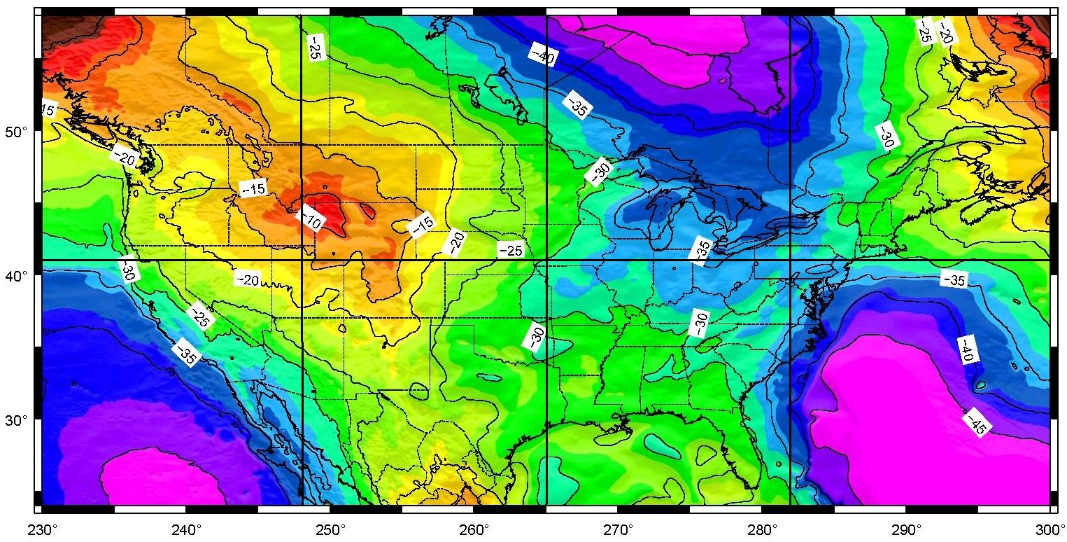
USGG2009BETA - Conterminous United States
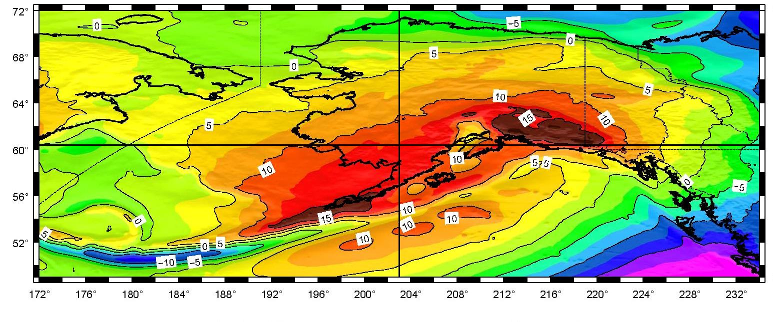
USGG2009BETA - Alaska
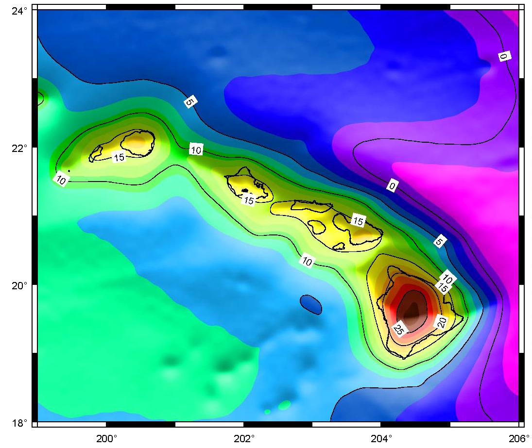
USGG2009BETA - Hawaii
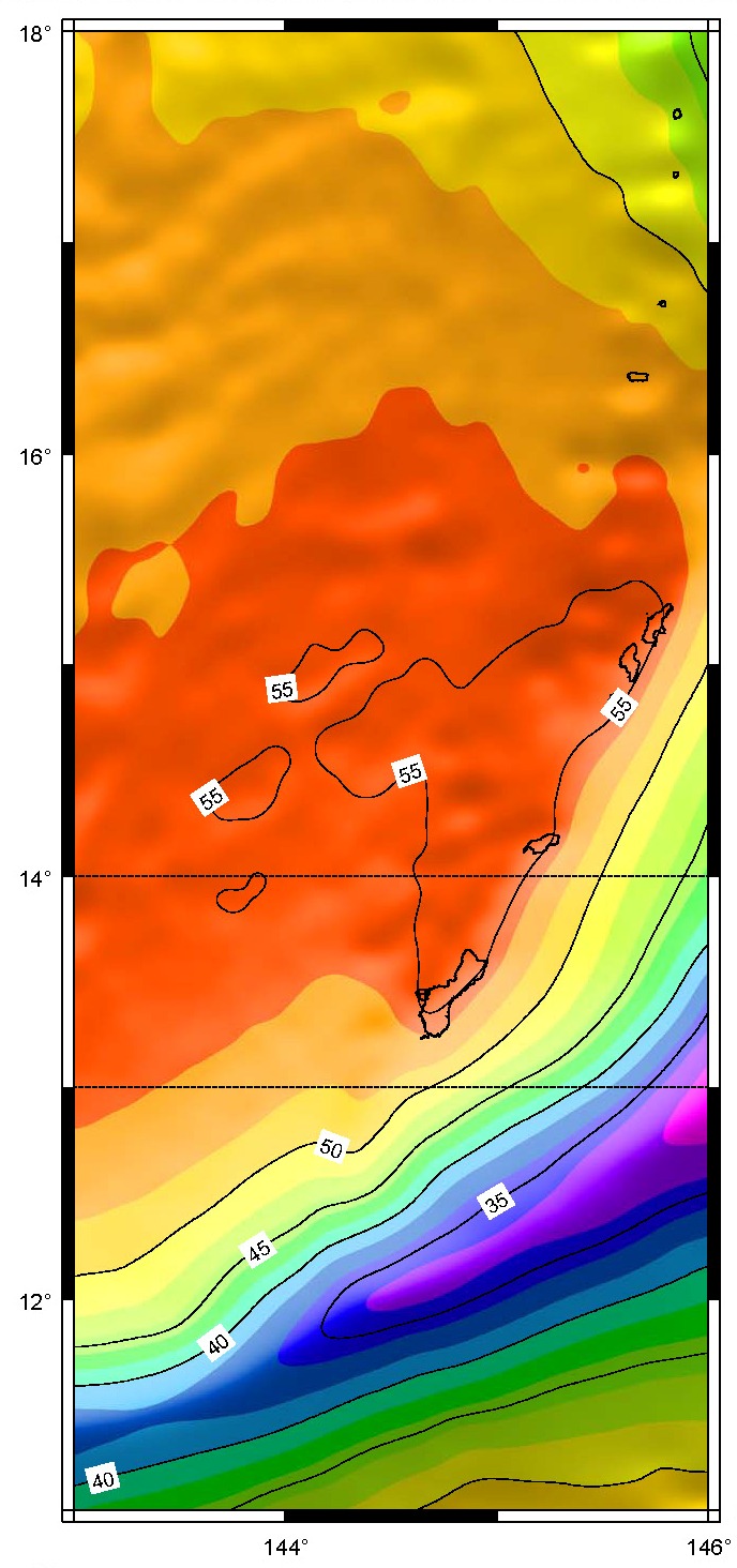
USGG2009BETA - Guam and Northern Mariana Islands
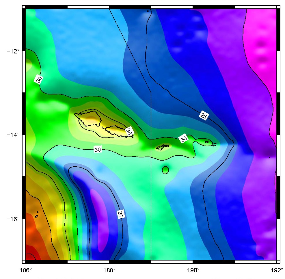
USGG2009BETA - American Samoa
BETA - DATA MODEL NOT RELEASED FOR PRODUCTION
Data (non-graphical interface)
Conterminous United States
- Binary Grids (all are 1141 columns by 1081 rows and are 4,933,728 bytes in size)
- Compressed ASCII grids
- Grid #1 (58 - 40 N & 230 - 249 E, size: 3,884,068 bytes)
- Grid #2 (58 - 40 N & 247 - 266 E, size: 3,964,988 bytes)
- Grid #3 (58 - 40 N & 264 - 283 E, size: 3,760,474 bytes)
- Grid #4 (58 - 40 N & 281 - 300 E, size: 4,113,430 bytes)
- Grid #5 (42 - 24 N & 247 - 266 E, size: 3,844,001 bytes)
- Grid #6 (42 - 24 N & 247 - 266 E, size: 3,964,488 bytes)
- Grid #7 (42 - 24 N & 264 - 283 E, size: 3,754,992 bytes)
- Grid #8 (42 - 24 N & 281 - 300 E, size: 3,947,009 bytes)
Alaska
- Binary Grids (all are 1921 columns by 721 rows and are 5,540,208 bytes in size)
- Compressed ASCII grids
- Grid #1 (60 - 72 N & 172 - 204 E, size: 4,007,323 bytes)
- Grid #2 (60 - 72 N & 202 - 234 E, size: 4,381,289 bytes)
- Grid #3 (49 - 61 N & 172 - 204 E, size: 4,392,003 bytes)
- Grid #4 (49 - 61 N & 202 - 234 E, size: 4,563,712 bytes)
Hawaii
- Binary Grid (421 columns by 361 rows; 607,968 bytes in size)
- Compressed ASCII grid
- Grid #1 (18 - 24 N & 199 - 206 E, size: 476,788 bytes)
Guam and Northern Mariana Islands
- Binary Grid (181 columns by 421 rows; 304,848 bytes in size)
- Compressed ASCII grid
- Grid #1 (11 - 18 N & 143 - 146 E, size: 232,559 bytes)
American Samoa
- Binary Grid (361 columns by 361 rows; 521,328 bytes in size)
- Compressed ASCII grid
- Grid #1 (17 - 11 S & 186 - 192 E, size: 426,866 bytes)
Puerto Rico and Virgin Islands
- Binary Grid (301 columns by 361 rows; 434,688 bytes in size)
- Compressed ASCII grids
- Grid #1 (15 - 21 N & 291 - 296 E, size: 476,788 bytes)
BETA - DATA MODEL NOT RELEASED FOR PRODUCTION
Disclaimer
|