| PID:
|
BBBB01 |
| Designation:
|
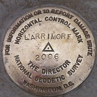
LARRIMORE |
| Stamping:
|
LARRIMORE 2006 |
| Stability:
|
May hold,commonly subject to ground movement |
| Setting:
|
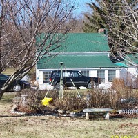
Object surrounded by mass of concrete |
| Description:
|
This station is established to posthumously commemorate National Geodetic Survey Lead Computer Specialist CRAIG B. LARRIMORE for his success in promoting access and maintenance for the National Spatial Reference System. This mark demonstrates the initial use of the internet to automatically upload, process, adjust, archive, and display field survey data, made possible through Craig's efforts.
Note: The station resides within a memorial garden on private property. Recovery is not recommended. |
| Observed:
|
2006-01-12T15:59:00Z |
more obs Original
|
| Source:
|
OPUS - page5 1209.04 |
|
|
|
| Close-up View
|
|
| REF_FRAME:
NAD_83(2011) |
EPOCH:
2010.0000 |
SOURCE:
NAVD88 (Computed using GEOID18) |
UNITS:
m |
SET PROFILE
|
DETAILS
|
|
| LAT:
|
39° 21' 51.77107"
|
± 0.019
m |
| LON:
|
-77° 46' 21.55804"
|
±
0.009
m |
| ELL HT:
|
98.923 |
±
0.021
m |
| X:
|
1045792.598 |
±
0.009
m |
| Y:
|
-4825830.607 |
±
0.024
m |
| Z:
|
4023736.628 |
±
0.017
m |
| ORTHO HT:
|
132.588 |
±
0.057
m |
|
|
UTM
18 |
SPC
4701(WV N) |
| NORTHING:
|
4360880.958m |
97391.754m |
| EASTING:
|
261128.820m |
748846.721m |
| CONVERGENCE:
|
-1.75938721°
|
1.10165396°
|
| POINT SCALE:
|
1.00030260 |
0.99995111 |
| COMBINED FACTOR:
|
1.00028708 |
0.99993559 |
|
|
|
|
| Horizon View
|
|
|
|
|