Following in the Footsteps of Lewis & Clark
Corps of Discovery II Markers
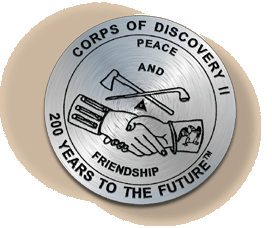 This brass Corps of Discovery II marker commemorates the symbolic start
of the Lewis and Clark expedition. Initiated by Thomas Jefferson, the
expedition began to explore and map America in 1803.
This brass Corps of Discovery II marker commemorates the symbolic start
of the Lewis and Clark expedition. Initiated by Thomas Jefferson, the
expedition began to explore and map America in 1803.
To honor Lewis and Clark's contributions to mapping, NOAA’s National Geodetic Survey (NGS) is installing a series of commemorative markers along the route that Lewis and Clark traveled, beginning in Monticello in Virginia and ending at Fort Clatsop in Oregon. NGS is positioning these markers using modern techniques, including the satellite-based Global Positioning System. The markers will become part of the National Spatial Reference System (NSRS), the federal standard and foundation for all positioning and navigation activities in the United States.
Jefferson: The Beginning
As the son of an active surveyor, Thomas Jefferson was exposed to the world of mapping and charting at an early age. Although Jefferson chose law as his profession, in 1773 he briefly considered a career as a surveyor. He was commissioned as the Albemarle County, Virginia, surveyor on October 14, 1773, but did not enter a complete survey into the books during his time of appointment. Even though Jefferson decided to go into law and then into politics, he realized the importance of surveying throughout his life, recognizing that a nation could not be newly built without an accurate system of reference points.
Jefferson’s desire to improve the land and the life of its inhabitants further fueled his aspirations for discovery and exploration. Jefferson saw an integral relationship between man and the earth, believing that the land was given to man to civilize and cultivate. In correspondence to James Madison, dated October 28, 1785, Jefferson writes "It is not too soon to provide by every possible means that as few as possible shall be without a little portion of land. The small landholders are the most precious part of a state.” Jefferson made this philosophy become reality through the order and consistency of surveying. He proposed a methodical plan to distribute equal amounts of land in the Northwest Territory, where disputes and confusion over land possession were common.
Sending Lewis and Clark on the Trail
Even before becoming president in 1801, Jefferson had dreamed of probing the uncharted West for many years. He was involved in several expeditions sent to find a water passage to the west coast of North America, but they were unsuccessful. Yet, these attempts gave Jefferson experience in exploration, providing a basis for his future pursuits of mapping unknown land. Jefferson’s presidency gave him the necessary resources to seriously consider exploration of the West. In his first 1801 inaugural address, he saw “A rising nation, spread over a wide and fruitful land, advancing rapidly to destinies beyond the reach of mortal eye.” Less than two years later, on January 18, 1803, Jefferson followed through with his vision, requesting $2,500 from Congress for the Corps of Discovery, which became known as the Lewis and Clark expedition.
In May 1804, as Lewis and Clark were about to move west along the Missouri River, Jefferson wrote, “We shall delineate with correctness the great arteries of this great country: those who come after us will fill up the canvas we begin.” While Jefferson directed Lewis and Clark to gather information about the people, animals, and plants of the West, one of his main objectives was to chart the territory, hoping to find a waterway to the Pacific Ocean. In his instructions to Meriwether Lewis, Jefferson writes, “Beginning at the mouth of the Missouri, you will take observations of latitude and longitude at all remarkable points on the river, & especially at the mouths of rivers, at rapids, at islands & other places & objects distinguished by such natural marks & characters of a durable kind, as that they may with certainty be recognized hereafter.”
The Survey of the Coast
 After the success of the Corps of Discovery expedition, Jefferson desired
to survey the Eastern coast of America, because shipwrecks commonly occurred.
With a clear delineation of the coastline, many products and ships could
be saved, expanding commerce and industry. An act was passed by Congress
on February 10, 1807, authorizing Jefferson to establish an organization
to survey the coasts of the United States.
After the success of the Corps of Discovery expedition, Jefferson desired
to survey the Eastern coast of America, because shipwrecks commonly occurred.
With a clear delineation of the coastline, many products and ships could
be saved, expanding commerce and industry. An act was passed by Congress
on February 10, 1807, authorizing Jefferson to establish an organization
to survey the coasts of the United States.
Be it enacted by the Senate and the House of Representatives of the United States of America in Congress assembled, That the President of the United States shall be, and he is hereby authorized and requested, to cause a survey to be taken of the coasts of the United States, in which shall be designated the islands and shoals, with the roads or places of anchorage, within twenty leagues of any part of the shores of the United States; and also the respective courses and distances between the principal capes, or head lands, together with such other matters as he may deem proper for completing an accurate chart of every part of the coasts within the extent aforesaid.
After analyzing the ideas of several surveyors, Jefferson chose Swiss-born Ferdinand Hassler to become the Superintendent of the new bureau, called the Survey of the Coast and directed by the Treasury Department.
In 1878, the agency was reorganized and given a new name, the Coast and Geodetic Survey (C&GS), which it maintained until 1970. The name C&GS acknowledged the importance of geodesy, the science concerned with measuring the size and shape of the earth, to surveying. In 1970, a reorganization created the National Oceanic and Atmospheric Administration (NOAA), and the National Ocean Service (NOS) was created as a line office of NOAA. Part of C&GS became the National Geodetic Survey, which is currently responsible for evolving and maintaining the National Spatial Reference System (NSRS).
Surveying Today with NOAA’s National Geodetic Survey
Today, the mission of NOAA’s National Geodetic Survey (NGS) is
to ensure that the United States has a consistent, high-accuracy geodetic
reference foundation that supports a 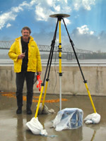 multitude
of needs. The safety and efficiency of the buildings we live in and work
in, the roads and bridges we drive on, and the trains, airplanes, and
ships that carry the products we use everyday, all depend on a universally
compatible system of geodetic reference points that tie our nation together.
Until recently, NGS has relied on using conventional line-of-sight survey
measurements, much like Lewis and Clark did, to provide this national
geodetic framework.
multitude
of needs. The safety and efficiency of the buildings we live in and work
in, the roads and bridges we drive on, and the trains, airplanes, and
ships that carry the products we use everyday, all depend on a universally
compatible system of geodetic reference points that tie our nation together.
Until recently, NGS has relied on using conventional line-of-sight survey
measurements, much like Lewis and Clark did, to provide this national
geodetic framework.
The advent of the Global Positioning System (GPS), however, has irreversibly transformed this landscape. Developed by the U.S. military, GPS is a constellation of satellites that transmit their signals to receivers all over the world. GPS enables geodetic positioning to be accomplished without having to physically see or measure distances between survey points. Using GPS, a survey that once took days or weeks to complete can now be done in a few hours at a much lower cost. GPS has not only revolutionized the traditional civilian navigation, surveying, and mapping professions, but has spawned numerous new applications in industrial sectors not previously dependent on geodesy. NGS provides the infrastructure that facilitates public and private civilian applications of GPS. The virtually unknown geography of western America, described as a blank canvas in Jefferson’s time, is now well documented by the framework of NSRS, and it can be viewed by all GPS and GIS users.